
Gooseneck State Park
Near Mexican Hat, UT
GOOSENECKS STATE PARK
A BRIEF SUMMARY OF GOOSENECKS STATE PARK
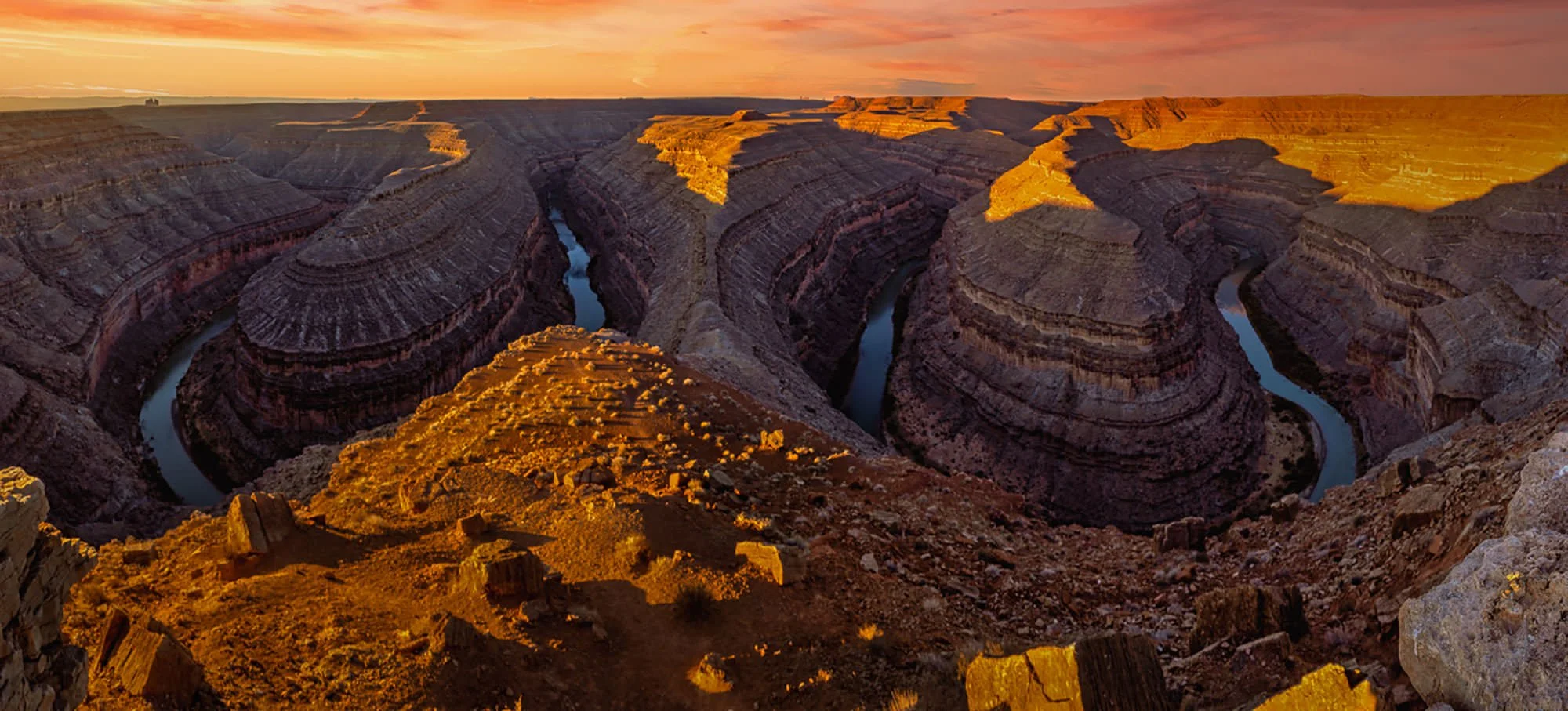
Goosenecks State Park is a unique location of exceptionally tight incised entrenched meanders, which is a 1,000-foot deep canyon that the San Juan River flows through.
This location offers a very different perspective and photographic experiences not found at the other popular meanders, such as Dead Horse Point State Park or Horseshoe Bend Overlook. This incredible canyon provides a view of six miles of the San Juan River tightly bending within a one and half a mile viewing landscape with a view of the overlook's spur with the canyon on either side. This site additionally offers an opportunity to camp alongside your shooting location.
Photos and location summary by Mark Asbury

Annual Subscription
Lifetime Membership
DATA POINTS INCLUDED WITH GOOSENECKS STATE PARK SUMMARY
While the prime shooting site is found at the overlook that you can park by and walk to, there is a way to drop into the canyon on the West side of the Overlook wall (see this path over-lay). Exercise caution along this path as there is a lot of loose rock and a bit of a grade. There are other compositions available, including a seasonal waterfall on the Eastern spur of the park that is visible after winter snowmelt or the spring rainy season, but a composition from the overlook, as shot in this illustration is the most common followed by those that make the drop are the two most common.
Two nuisances are prevalent to plan for that are also somewhat typical elsewhere.
• Recreator’s interjecting into the image. Recreator’s interjected themselves accidentally into a photographer’s composition.
• Camper’s Night Light Discipline. Though the park is in a dark night area, light spillage from campers and campfires may affect nighttime photography.
This is definitely an ultra wide-angle lens location. To photograph both of the visible meanders as shown, it is best achieved using a panoramic shooting technique. This is how this image was shot. I used a 24-240mm lens with a perpendicular mounting on a panoramic head where 15 overlapping pan images were taken, then stitch together for a composite image.
The above image was taken with a 30mm lens
4,957 Ft. Elevation
Other Resources Available with Membership
KMZ Trail File
Directions
Best Time of Day to Shoot
Best Time of Year to Shoot
Equipment Needed
Permits Required
Direction of Shot
Google Maps Birds-Eye-View
Number of Photographers to Expect
Cell Service
Overnight Lodging/Camping
Nearby Restaurants
Area Guides and Workshops
Other Resources
LOCATION SUMMARIES WRITTEN BY PROFESSIONAL PHOTOGRAPHERS


