
Gooseneck State Park

GOOSENECKS STATE PARK
Near Mexican Hat, UT
Image by Mark Asbury @ sonyphotographer.info
Goosenecks State Park is a unique location of exceptionally tight incised entrenched meanders, which is a 1,000-foot deep canyon that the San Juan River flows through.
This location offers a very different perspective and photographic experiences not found at the other popular meanders, such as Dead Horse Point State Park or Horseshoe Bend Overlook. This incredible canyon provides a view of six miles of the San Juan River tightly bending within a one and half a mile viewing landscape with a view of the overlook's spur with the canyon on either side. This site additionally offers an opportunity to camp alongside your shooting location.
Photos and location summary by Mark Asbury
Trail Difficulty - EASY
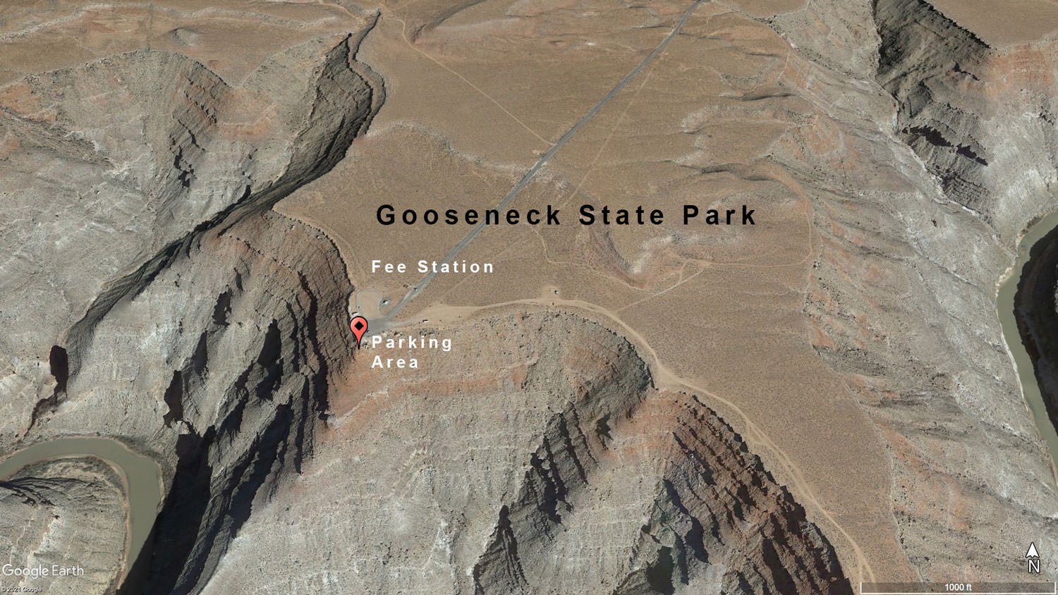
While the prime shooting site is found at the overlook that you can park by and walk to, there is a way to drop into the canyon on the West side of the Overlook wall (see this path over-lay). Exercise caution along this path as there is a lot of loose rock and a bit of a grade. There are other compositions available, including a seasonal waterfall on the Eastern spur of the park that is visible after winter snowmelt or the spring rainy season, but a composition from the overlook, as shot in this illustration is the most common followed by those that make the drop are the two most common.
GPS Coordinates & Elevation
4,957 Ft. Elevation
Google Earth
Download KMZ Trail File
Click Here to download the KMZ file for this location.
Directions
CLICK HERE to get driving directions to Gooseneck State Park
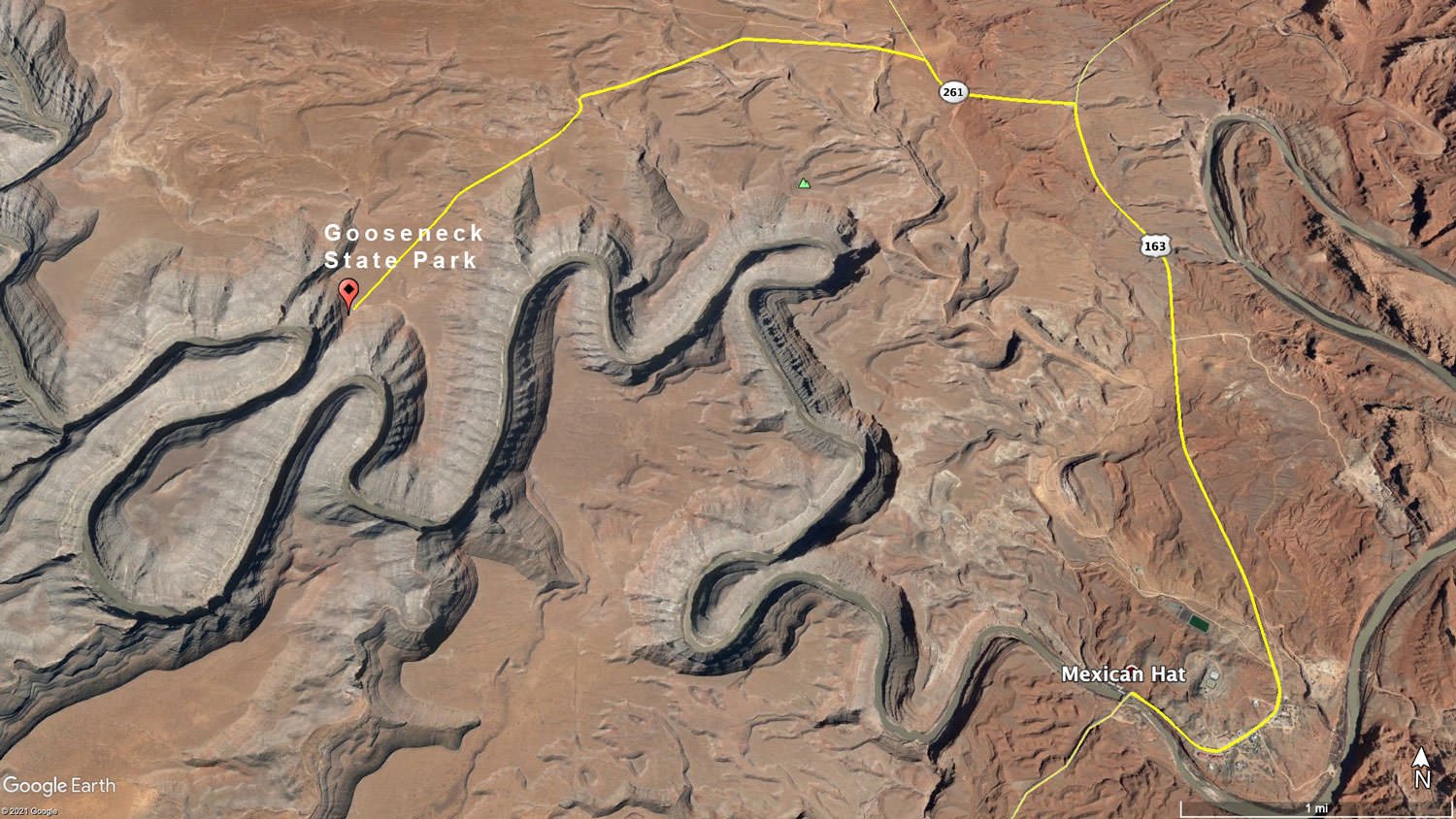
From Mexican Hat, UT - drive north on US-163 N for approximately 4.0 miles until you come to UT-261N. Take a left and drive for approximately 1 mile until you see at the turnoff for Gooseneck State Park (UT-316). At the turn, drive 3.5 miles and you will be at Gooseneck State Park.
From Monument Valley - drive north on US-163 N for approximately 26 miles (through Mexican Hat, UT) until you come to UT-261N. Take a left and drive for approximately 1 mile until you see at the turnoff for Gooseneck State Park (UT-316). At the turn, drive 3.5 miles and you will be at Gooseneck State Park.
The location of the shot is directly from a walk-out from the parking lot at Gooseneck State Park.
Photography Tips
Two nuisances are prevalent to plan for that are also somewhat typical elsewhere.
• Recreator’s interjecting into the image. Recreator’s interjected themselves accidentally into a photographer’s composition.
• Camper’s Night Light Discipline. Though the park is in a dark night area, light spillage from campers and campfires may affect nighttime photography.
EXIF Data
Focal Length – 30 mm
Exposure – 60th sec @ f 8.0
ISO – 100
Date – Nov 19th
Time – 5:45 pm
Best Time of Day to Shoot
The best time to shoot is a challenging concept, which largely depends upon the desired outcome. Blue hour in the morning and evening offers a soft light that reveals detail through long exposure. Golden hour offers an exceptional parallel surface light, but the only cast reflected light onto the canyon demanding multi-exposure for the highlights and shadows. The good news is that canyon exposure ranges aren’t yet at an extreme shadow differential. The real value of Golden hour shooting is the dramatic sky colors.
Based upon the depth of the canyon, mid-day sunlight offers harsher lighting but does cast light downward into the canyon. This period of lighting works well for travel photography. This period becomes more dramatic when the sunlight is traversing as backlighting that is noticeable during the months between May and September.
Best Time of Year
You can shoot this location year-round. However, road conditions in winter might make it inadvisable to visit. During the spring rainy season, the soil outside the asphalt area and gravel road it often extremely muddy. If you can negotiate the mud, then a waterfall on the Southern canyon wall can be found on the East peninsula in the park. Outside of that, the best time of the year depends on your photographic interest. Note: Milky Way hunting season is April – August.
The above image was taken on November 19th
Lens(es) Needed
This is definitely an ultra wide-angle lens location. To photograph both of the visible meanders as shown, it is best achieved using a panoramic shooting technique. This is how this image was shot. I used a 24-240mm lens with a perpendicular mounting on a panoramic head where 15 overlapping pan images were taken, then stitch together for a composite image.
The above image was taken with a 30mm lens
Birds-Eye View From Google Earth Pro
Permits
Here are the costs to enter the park: a $ 5.00-day use fee per car with up to 8 people or a $2.00 per person fee for bus tour groups. If no ranger is on duty, pay at the fee tube using a self-service envelope.
Direction of the Shot
The direction of the shot is south by southwest at around 200°.
Equipment Needed
Bring a sturdy tripod for long exposures and panoramic shoots and a remote shutter trigger. Other useful photo gear is a circular polarizing filter and a UV filter.
Number of Other Photographers to Expect
During tourist season you'll find tour buses making short stops during the daylight hours as well as other travelers, who merely make the short visit to gaze and mostly do selfies with the canyon in the background.
Weather
Gooseneck State Park is in an arid part of the Arizona/Utah desert, as has an elevation of 4,700ft. For the most part, the weather is modest with highs in the summers of the upper 90s and lows in winter in the 20s.
Cell Service
Verizon has solid 4G LTE coverage, and AT&T reports off-net coverage while at Gooseneck State Park
Overnight Camping Options
There is a small (8 sites) camp facility at Gooseneck State Park. It is primitive and the fee at the time of this writing is $10 per night.
From Gooseneck, you are only 22 miles from Monument Valley - where there is plenty of lodging available.
Nearby camping and lodging
Camping - click on the campground below for directions
The View Mitten Campground – Monument Valley Navajo Tribal Park
Goulding's Campground – 6 miles west in Oljato-Monument Valley
Lodging - click on the lodging below for a TripAdvisor review
The View Hotel
(435) 727-5555
Indian Rte 42, Oljato-Monument Valley, AZ
Goulding's Lodge
(435) 727-3231
1000 Main Street, Oljato-Monument Valley, UT
Nearby Restaurants
The closest town/community to Gooseneck State park is Mexican Hat and Monument Valley (22 miles away). In Mexican Hat, there is also a pretty good steak restaurant called The Swingin Steak. It is not going to change your life, but they make a pretty good steak and it is an interesting concept. It is not open year round, so call before driving there.
In Monument Valley there are a few more food choices.
Nearby Restaurants - click on the restaurant below for yelp review
The Swingin Steak
(435) 683-2222
2265 US-163, Mexican Hat, UT
The View Restaurant
(435) 727-5555
Monument Valley, AZ
Goulding's Stagecoach Dining
(435) 727-3231
Oljato-Monument Valley, UT
Area Guides and Workshops
None