
The Overlook

THE OVERLOOK
Near Hanksville, UT
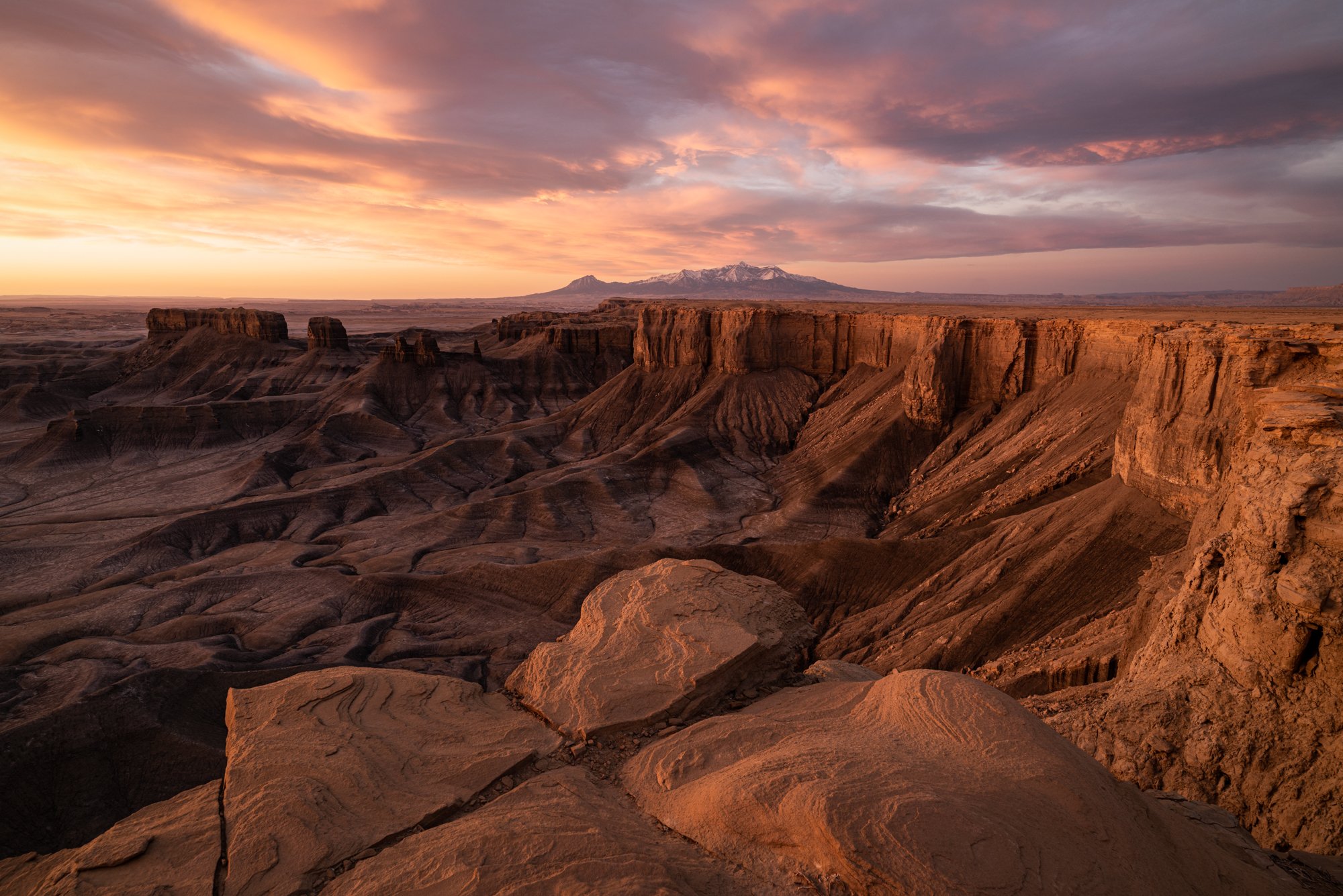
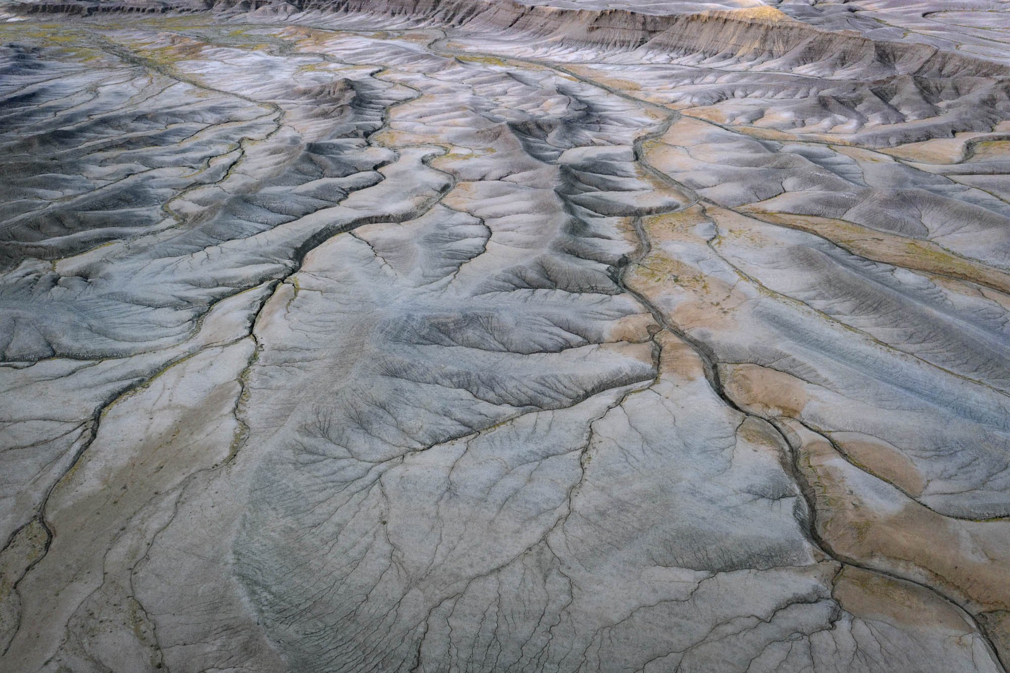
Utah is one of the most photographically fertile areas in the American southwest - with ever ending abstracts, buttes, formations, striations, and jaw-dropping vistas. And this location, overlooking the astonishing badlands near Hanksville, UT is just another example of the amazing natural beauty this area has to offer.
The area west of Hanksville, UT (seen by many as lifeless and barren badlands) provides for some of the most unusual topographical abstracts found anywhere in the American southwest. And from this location (sometimes called the Moonscape overlook) you have a grand view of the unlimited extraterrestrial like terrain that stretches as far as the eye can see.
Images and location summary by Tim Wier
Trail Difficulty - MODERATE
I would rate the difficulty of this trail as a 2.5 on a scale of 1-5 (with 5 being most difficult). The main road (Coal Mine Rd) is rough in a few spots, and the dirt road that takes you to the overlook can be a bit bumpy. However, the walk from the parking area to the location of the shot is an easy 25 yds.
NOTE: the dirt road to this location can be impassable when the ground is wet/muddy.
GPS Coordinates & Elevation
4,653 Ft. Elevation
Google Earth
Download KMZ Trail File
Click Here to download the KMZ file for this location.
Directions
CLICK HERE to get driving directions to the Badlands (Moonscape) overlook.
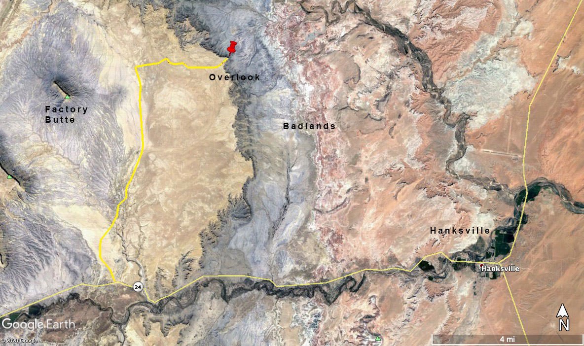
The closest town is Hanksville, UT which is located in south central Utah.
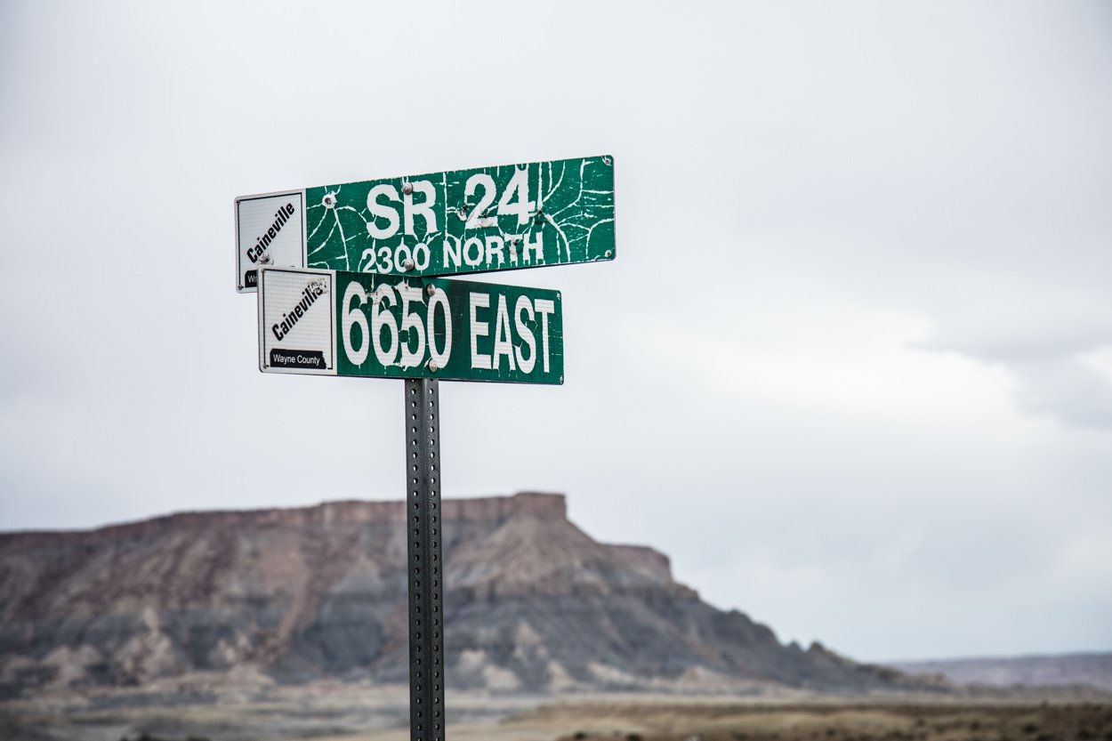
From Hanksville, travel west 10.6 miles on UT-24 until you get to a street sign that says 6650 EAST (this is Coal Mine Rd). Take a right - From Coal Mine Rd travel 6.1 miles until you see a dirt road BLM 0913. Turn right and follow this dirt road EAST for 2.7 miles until you reach the overlook of the Badlands. The overlook is just a few yards from the campground.
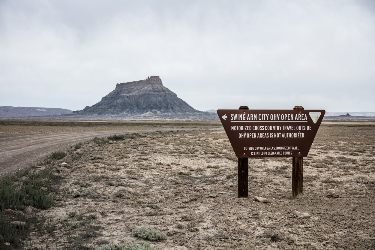
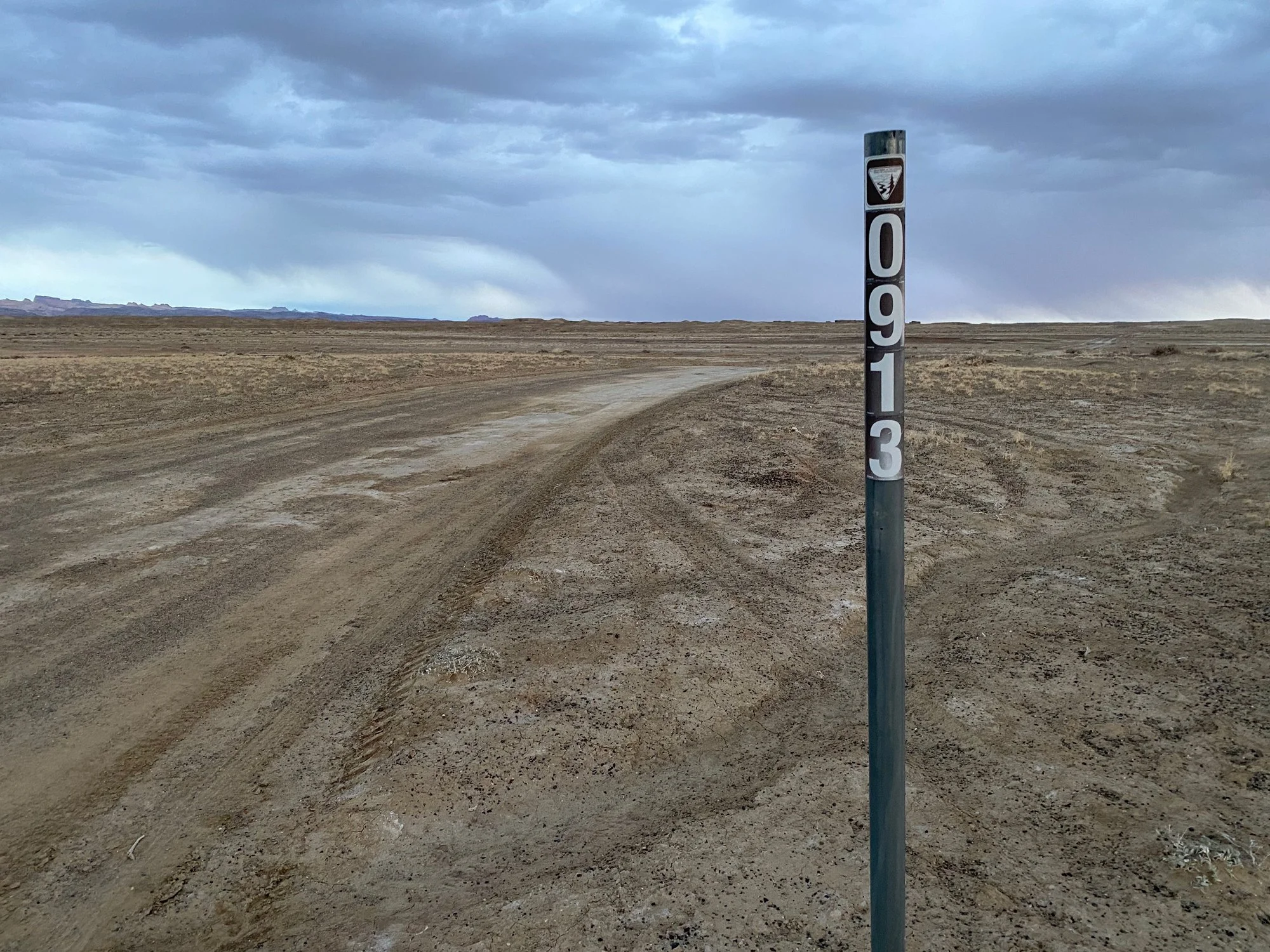
Don’t be confused by the 1st BLM 0913. The best road is the 2nd BLM 0913 which is 5.7 miles from the turnoff from UT-24.
IMPORTANT: the road(s) going to the Overlook can be confusing. There are 3 separate dirt roads that will take you to the Overlook from Coal Mine Rd (see graphic below). Two of the roads are currently labeled BLM 0913 and the other one is labeled BLM 0931. As mentioned, each of the roads will get you there. However, the best road is the 2nd BLM 0931 as it is packed down pretty well and has limited sandy areas. This is important if this area has recently had snow or rain.

I would suggest directing yourself to 38°27'5.80"N 110°50'16.64"W and/or downloading the KMZ file above to make sure you don’t get lost. Also, if you are gong to shoot sunrise at this location, it would be prudent to scout out the location the day before to find the composition that works for you. Driving to this location for the first time in the middle of the night might end up being frustrating.
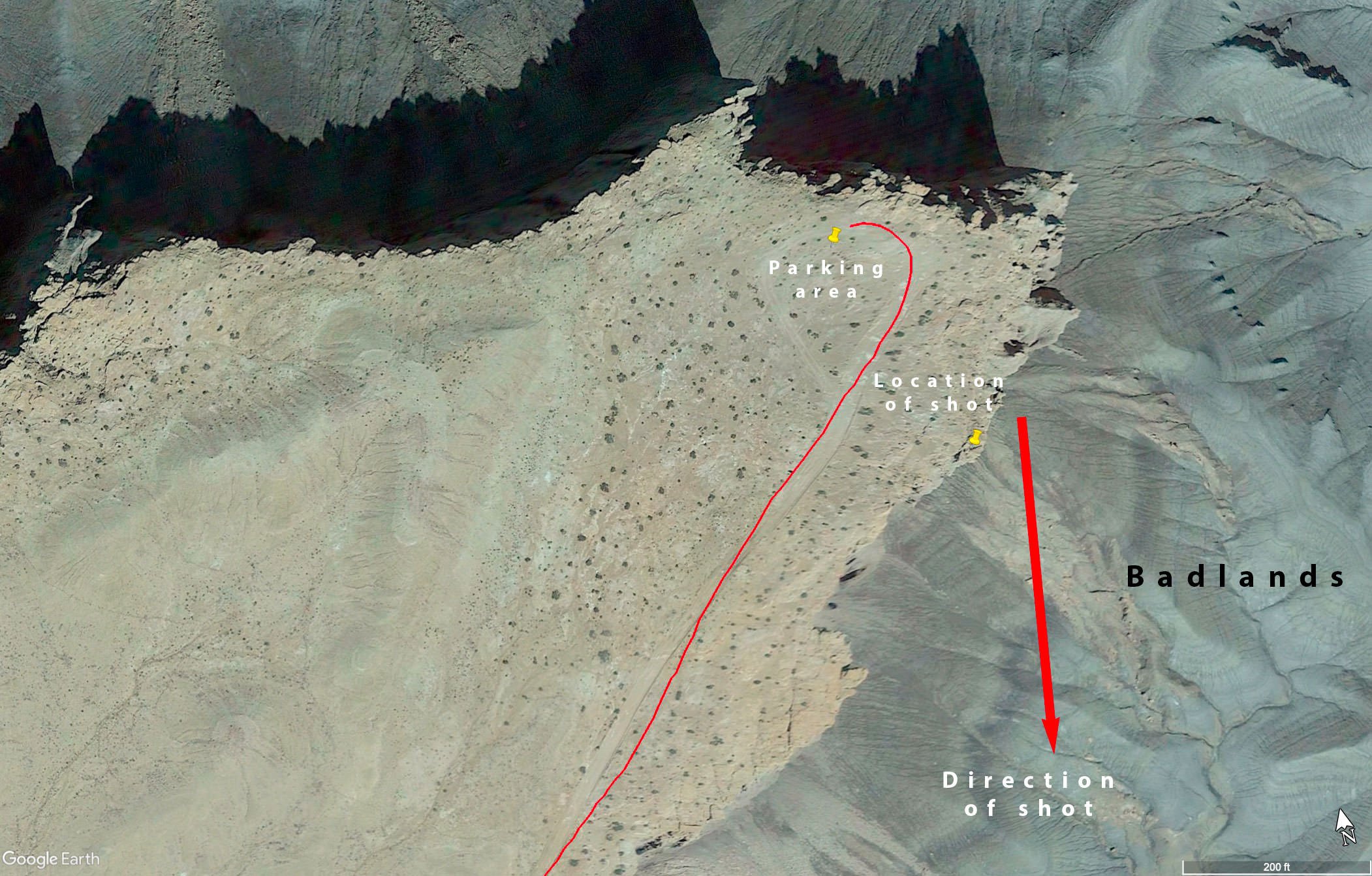
If you are using Google maps, follow directions to the turnoff and turn right on the dirt road. Follow the dirt road for 2.7 miles until you get to the Overlook. There are a couple of forks along the way, but just stay traveling EAST until you can go no further. At the end of the dirt road, there is a turnaround and a small campsite. The shot above was taken just off of the parking/camping area around sunrise.
Photography Tips
From this location, there are several compositions you may consider (with different angles, focal lengths and foregrounds). For this reason, you may want to either scout out the location the day before or arrive a half hour or so before sunrise to find the spot that works for you. If possible, try to find the right location to include the side (right) walls as they start to illuminate.
The sky and the side wall will illuminate at different times, so you may need to blend them together in post processing.
EXIF Data
Focal Length – 16 mm
Exposure – 1/8 th sec @ f 8.0
ISO – 100
Date – Aug 16th
Time – 5:46 am
Other Images From This Location
Best Time of Day to Shoot
This location is great at either sunrise or sunset. I prefer SUNRISE, because of the red glow on the side walls just as the sun crests the horizon.
If you like drone shots, this place is one of the VERY BEST locations in the southwest. The aerial shots of the badlands are something out of a sci-fi movie. A nice time for drone shots is an hour or so before SUNSET as the valley floor comes into shadow and the patterns explode.
Best Time of Year
You can shoot the badlands overlook any time of year. However, the red glow on the side walls is best during April - Sept. In the winter, the sun rises in the southeast (which means you are shooting directly into the sun).
Lens(es) Needed
You can shoot this location with anything from an ultra-wide to a standard lens. I would your widest lens up to a standard 50mm lens.
The above shot was taken at 16mm.
Birds-Eye View From Google Earth Pro
Permits
At this time, there are no permits required in the area.
Direction of the Shot
The direction of the shot is southeast around 150°.
Equipment Needed
No need for any special photography equipment (other than a sturdy tripod and a polarizer) unless you plan on doing a panoramic shot. You may also want to consider using a tilt/shift lens to compensate for the keystone effect while pointing down toward the valley floor.
A headlamp or flashlight is very helpful if you are shooting at early morning or twilight. If you are shooting on the ledge, it is always important to know where you are - as a fall from here would be catastrophic.
Number of Other Photographers to Expect
The area around Factory Butte is seeing more photographers than in past years, but the badlands/moonscape overlook is off the beaten path and there is a good chance you won’t see many other folks at sunrise/sunset.
Weather
The area around Factory Butte/Badlands is the high desert climate at about 4,800 ft. elevation. The temperatures can vary up to 30° - 40° a day. Spring and fall are nice, but summer can get into the high 90s.
Cell Service
I have Verizon and the cell service from this location is spotty. A stronger cell signal is available as you approach Hanksville.
Overnight Camping Options
There are 2 motels and 2 RV Parks in Hanksville and 1 hotel in Caineville.
Camping - click on the campground below for directions
Duke's Slickrock Campground & RV Park – 275 E Highway 24, Hanksville, UT 84734
Lodging - click on the lodging below for a TripAdvisor review
Muddy Creek Mining Company
(877) 711-3857
280 E 100 N, Hanksville, UT
Whispering Sands Motel
(435) 542-3238
90 South HW 95, UT
Nearby Restaurants
Hanksville is the closest town and there are a few places to eat there. After a morning shoot, I enjoy a good breakfast (biscuits and gravy) at Duke’s Slickrock Grill in Hanksville. They have great food, and nice people run the place. Stan's Burger Shak makes a good hamburger and a hardy shake, and the Outlaw’s Roost makes great tacos.
Nearby Restaurants - click on the restaurant below for yelp review
Duke’s Slickrock Grill
(435) 542-3235
Stan's Burger Shak
(435) 542-3330
Outlaw’s Roost
(435) 542-1763
Area Guides and Workshops

Melvin Perc @ Meridan Tours 954-907-6259
NoneMany areas around Hanksville are wonderful to photograph, but they can only be visited with a high-clearance vehicle. Several outfitters, guides, and tour companies take you to remote places for photography tours or overnight stays.
I have used Melvin Perc at Meridian Tours (954-907-6259) and really enjoy his knowledge of the area and time he takes to make sure your experience is first rate (NOTE: I have no relationship with Mel and pay full price when using him for tours).