
Wahweap Sunrise

WAHWEAP SUNRISE
Near Big Water, UT
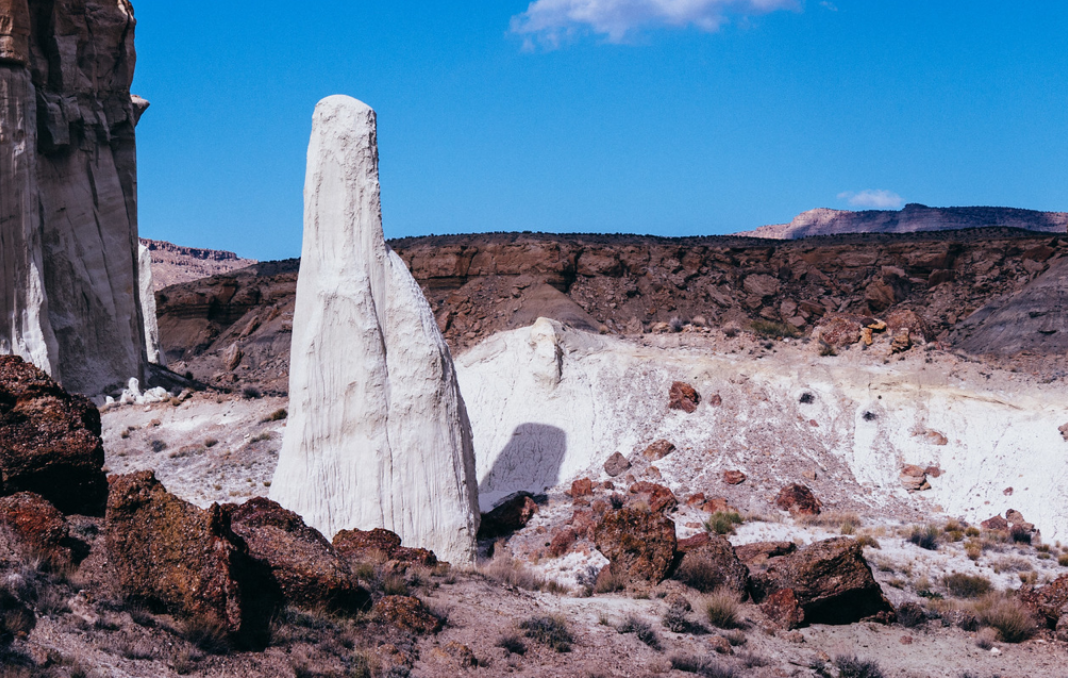
The ghostly white Wahweap Hoodoos are some of the most fascinating hoodoos found anywhere in the American Southwest. This unique location was made famous by Michael Fatali's (known now as Light Hunter) masterpiece "Stone Temples," and it does not disappoint.
The location is sometimes also referred to as "Towers of Silence." Regardless of what it is called, this place is simply magical! Just witnessing this natural event is incredible - but being there when the first light hits the hoodoos and frames this glowing scene is almost unbelievable – leaving you wondering, "how did this happen."
Once again, the American Southwest provides some of the most beautiful nature scenes found anywhere.
This extraordinary place is delicate and fragile. I would ask that when you visit, please do your best to preserve all aspects of this location for future visitors and always try to leave it in better shape than when you found it.
Images and location summary by Tim Wier
Trail Difficulty - CHALLENGING TO DIFFICULT
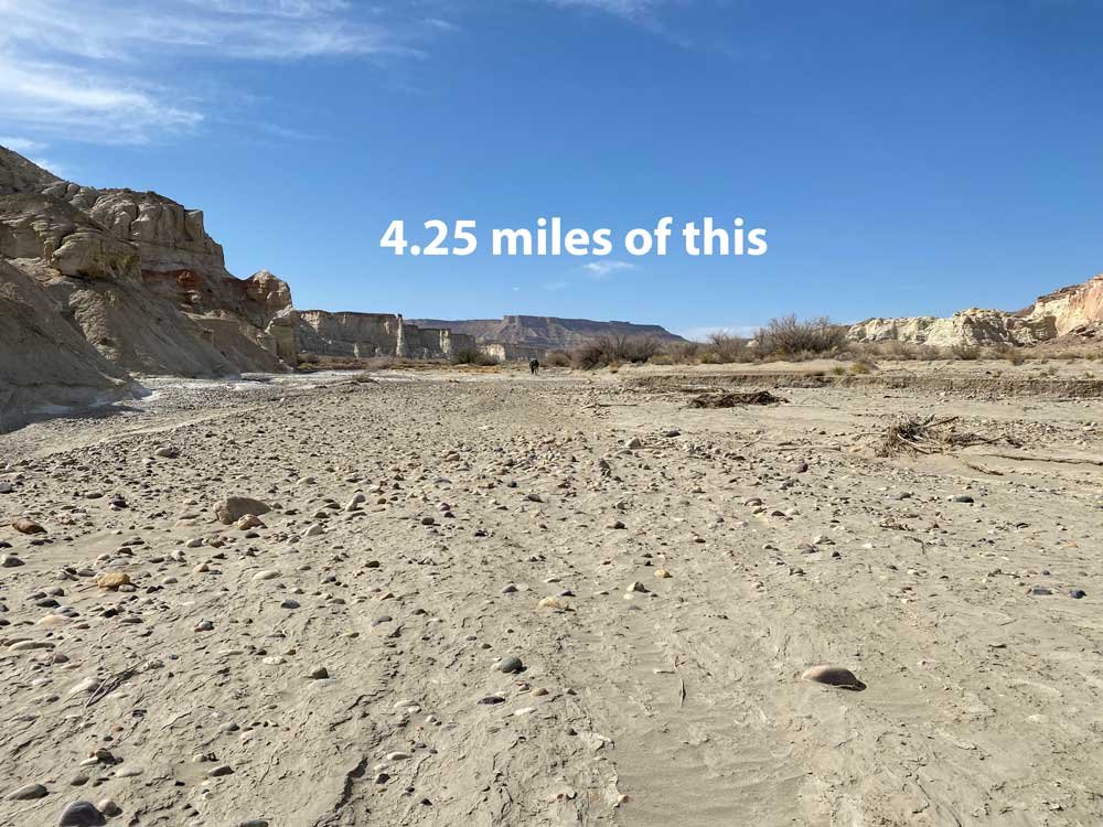
The hike to the Wahweap Hoodoos is not hard, but it is a long walk (4.25 miles each - 9.5 round trip) in a river wash. I would rate the difficulty of this trail as a 4 on a scale of 1-5 (with 5 being the most difficult). For the most part, the hike is level/flat but there are places where you are walking in sand or river stones, which can irritate your feet. And you are completely exposed for the entire hike - no shade, trees, or many places to rest. The walk takes about 2 to 2.5 hours each way.
I hiked it in mid-April, and the temperatures were modest but got warm on the return hike. I would NEVER recommend this hike during the SUMMER as the heat is extreme, and you would be putting yourself at risk.
Hiking the trail over two days (going up the afternoon before and returning the next morning) or hiking the up and back on the same day - are discussed below in "Equipment Needed"
GPS Coordinates & Elevation
4,298 Ft. Elevation
Google Earth
Download KMZ Trail File
Click Here to download the KMZ file for this location.
Directions
CLICK HERE to get driving directions to the parking area for the Wahweap Hoodoos
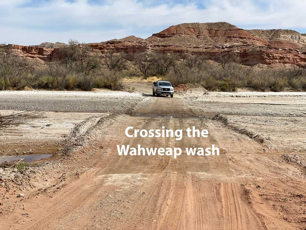
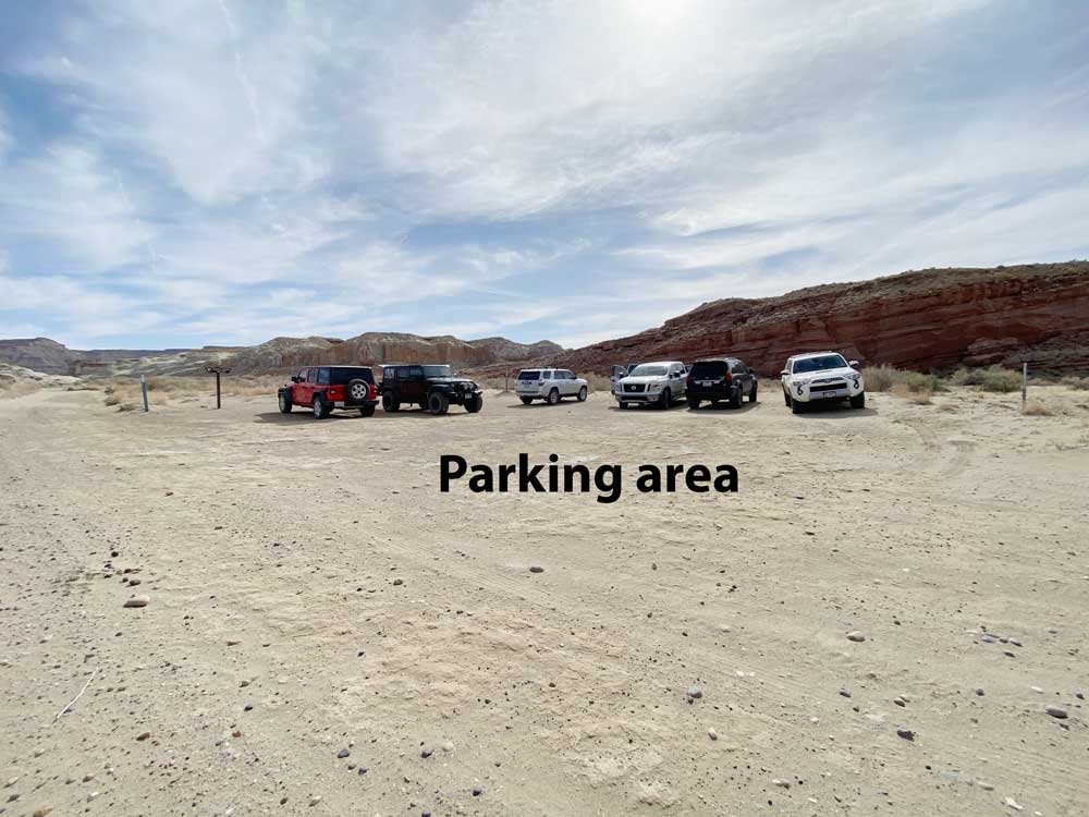
From Page, AZ - drive north on US-89 (passing over Glen Canyon Dam Bridge) for 16 miles (crossing into Utah) until you reach Big Water, UT. In Big Water, turn right on Ethan Allen, drive for 0.6 miles, and turn left onto Fish Hatchery Rd (a gravel road). Follow the Fish Hatchery Rd for 2.5 miles along the ponds of the Fish Hatchery until you reach the Wahweap wash crossing (the last mile or so, the road turns from gravel to sand). If the wash is passable, you can drive another .7 miles until you see a small parking area to the right. If the wash is not passable, you can park on the dry side of the Wahweap wash and walk.
From Big Water, UT - take Ethan Allen road for 0.6 miles and turn left onto Fish Hatchery Rd (a gravel road). Travel on Fish Hatchery Rd for 2.5 miles until you come to the Wahweap wash (after about 2.0 miles, the Fish Hatchery Rd goes from gravel to sand). If the wash is passable and you have a high clearance vehicle, you can drive another .7 miles until you see a small parking area to the right. If the wash is not passable, you can park on the dry side of the Wahweap wash and walk.
Hiking the trail to the Wahweap Hoodoos
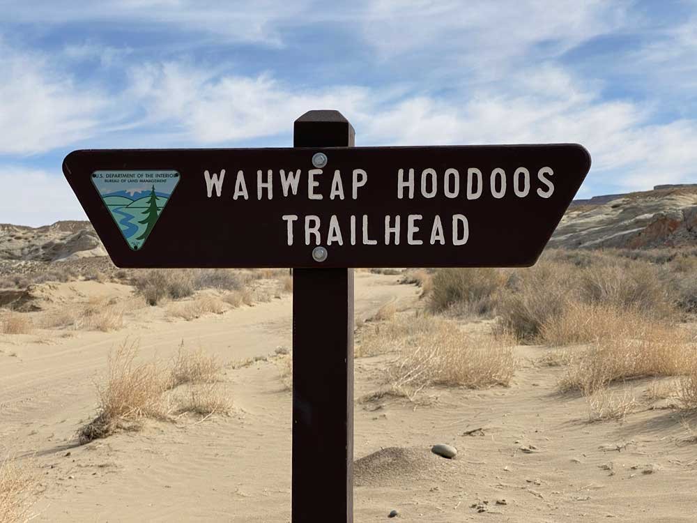
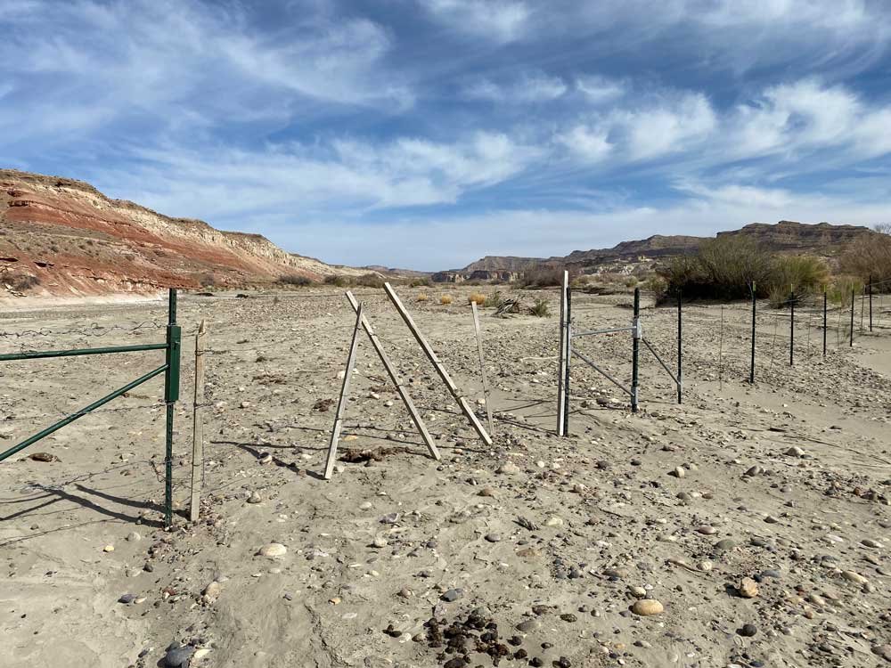
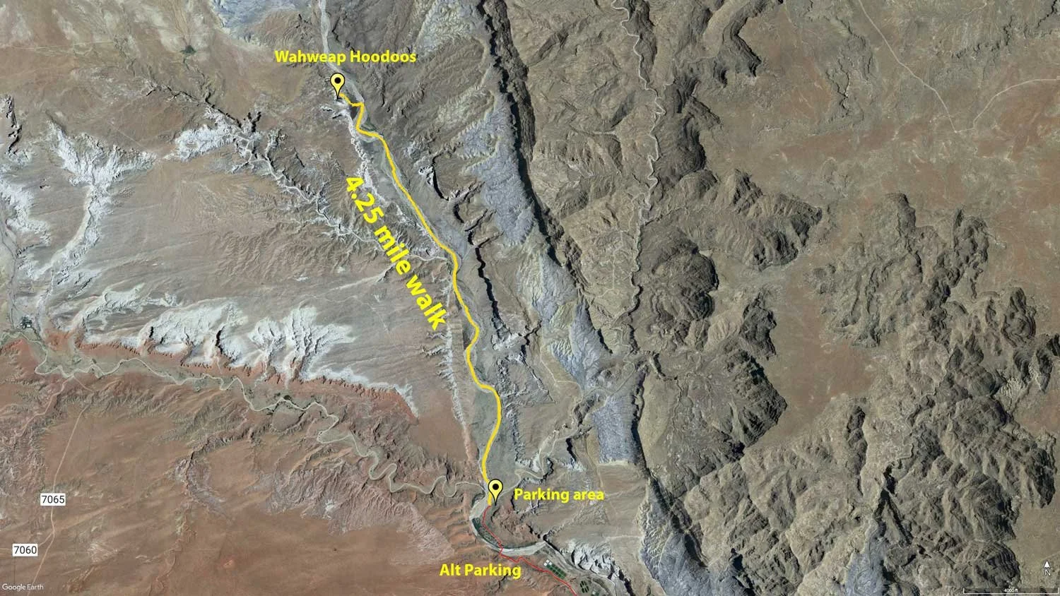
From the small parking area (see the sign above), walk down the sandy mound into the Wahweap wash and walk north by northwest for approximately 4.25 miles. After roughly a half mile in the wash, you will come to an old "hanging fence" - which is suspended over the creek bed. Continue past the fence hiking north, heading for the large "red buttress" on the eastern side of the creek. Around the 2.5-mile mark, you will see white hoodoos on the wash's west (left) side. At around 4 miles, you will see the first set of hoodoos.
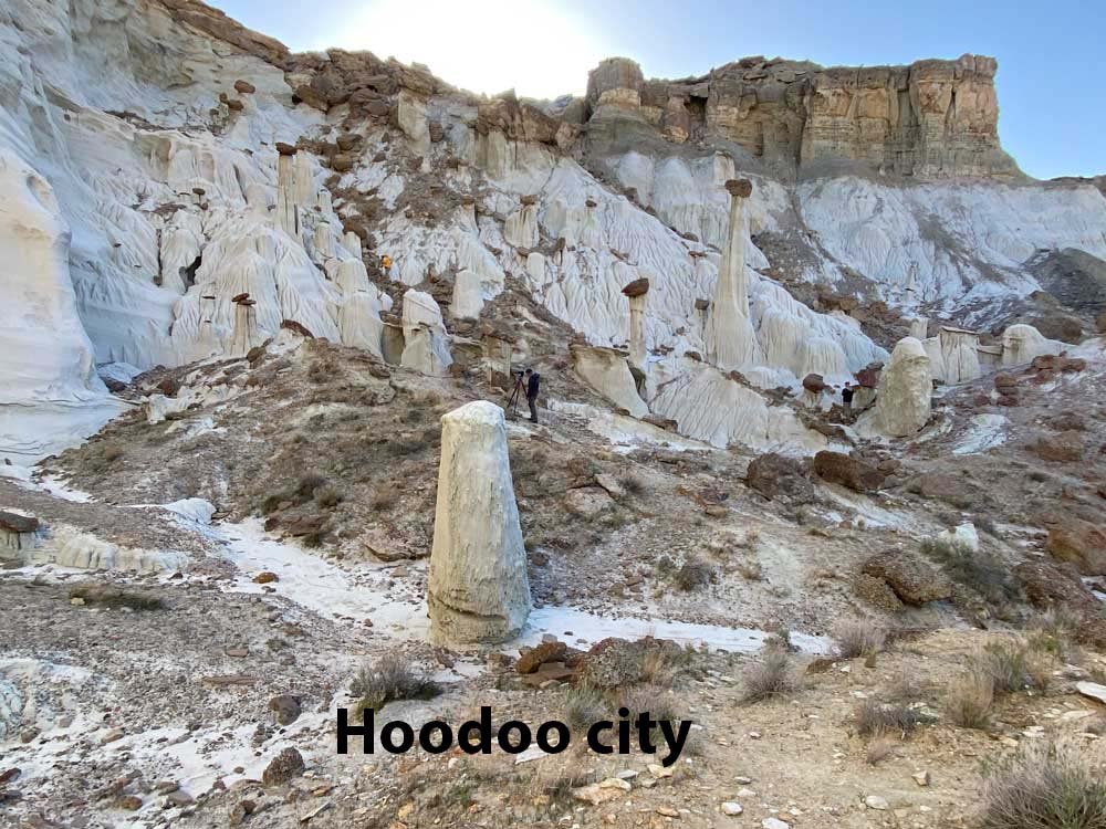
There are three sets of hoodoos along the cliff to your left (west side). Each group is separated from the others by a few hundred yards. Don't spend too much on the first group. The second group has a few more picturesque hoodoos, but the last group is where the Stone Temples or the Towers of Silence if found. You will know when you are at the correct set of hoodoos when you come to a very tall, large white spire on the left side. The Stone Temple / Towers of Silence is back and to the left of this large white spire.
Finding the location of the shot
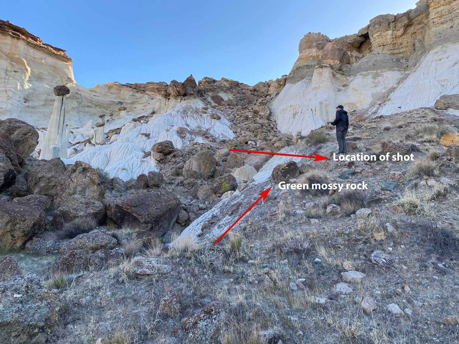
The location of the image above is part of a small but very interesting-looking hoodoo city with 20-30 different-sized hoodoos with dark brown rocks sitting on top of many of them. You can't miss the primary hoodoo, The Stone Temple / Towers of Silence. To find the location to take the shot, look north of the main hoodoo about 30 yds or so, and you will see a small rocky ridge that gets you at about the same heights as the primary hoodoo. Look for a medium-sized rock with bright green moss on it. Just above the mossy rock is where the image above was taken.
The north entrance is CLOSED. Do not attempt to go this way!
In the past, the Wahweap Hoodoos were accessible from the north by driving north on Cottonwood Canyon road, then east on BLM road 431. This was a much shorter route, requiring only a one-mile southbound hike to reach the hoodoos. Some places on the internet incorrectly list this as a viable route. IT IS NOT.
The BLM has closed road 431 to the public indefinitely. Some visitors used this backroad to drive their vehicles down into the wash, which is strictly prohibited. The BLM actively monitors this area, and bypassing the closure would likely result in hefty fines. The south trailhead and 4.25-mile hike is the only way to reach the hoodoos.
Photography Tips
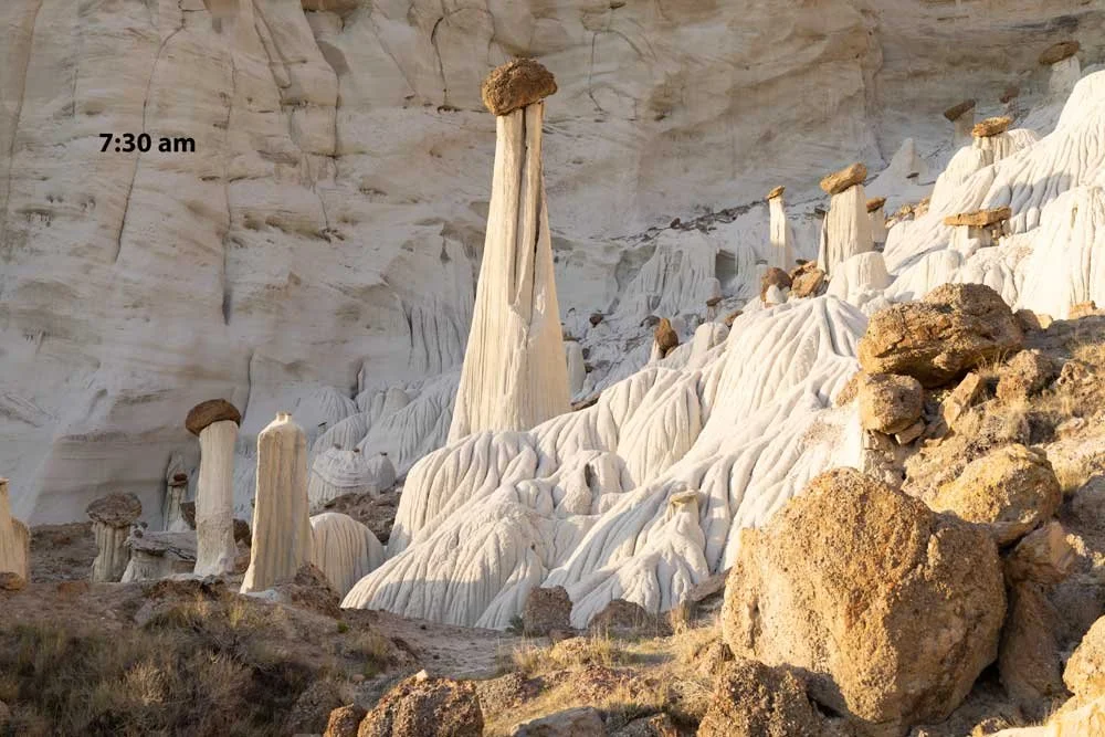
The shot above is pretty straightforward. Find your composition, put your camera on a sturdy tripod, make sure your focus is correct - and be ready to shoot just after the sun crest the horizon to the east.
Before visiting the Wahweap Hoodoos, I thought I would need to exposure bracket and blend images to capture the contract between the bright hoodoos and the back wall. As it turned out - a single exposure was all that was needed. The light will change about 4-6 f-stops from sunrise to the point when all the hoodoos are in full sun - so I still would exposure bracket (1 - 3 f stops on both sides) to make sure you capture the correct exposure.
The shot above is only one of many compositions for this unique location. However, the light moves fast, so I would suggest having your composition(s) in mind early in the morning and being able to respond quickly.
EXIF Data
Focal Length – 48 mm
Exposure – 60th sec @ f 8.0
ISO – 100
Date – April 14th
Time – 7:30 am
Best Time of Day to Shoot
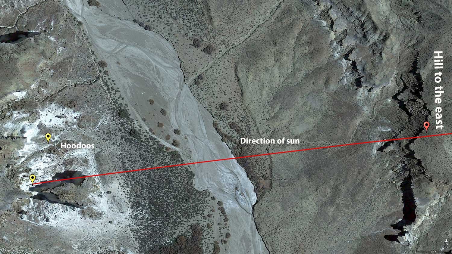
You can shoot the area around the Wahweap Hoodoos (many other hoodoos and formations) in the evening or early morning and get some nice shots. However, the image above only happens over a few minutes in the early morning (30 minutes or so after the stated sunrise) - when the sun crest the hill to your left/east and only during the right time of the year - see below - "Best Time of Year".
TIMING IS EVERYTHING
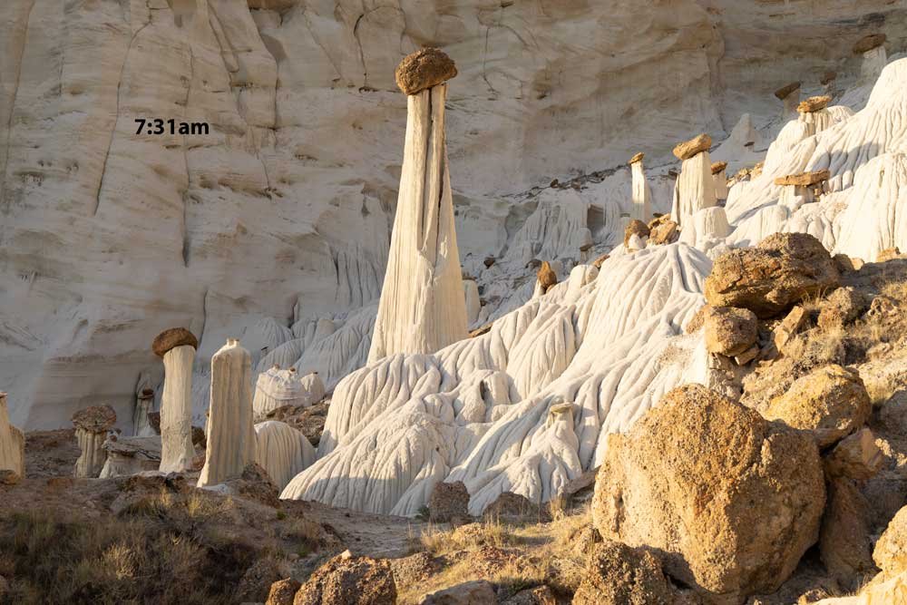
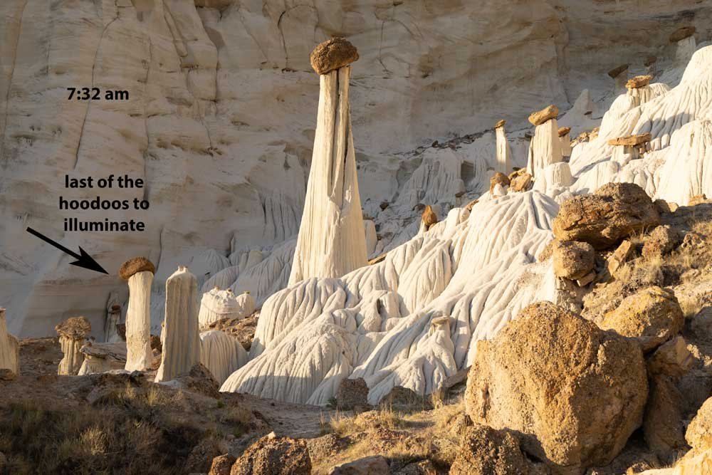
As stated, a tall ridge/hill to the east blocks the sun from hitting the hoodoos for about 30 minutes after the indicated sunrise time. Once the sun peaks over the hill, it takes another 5 minutes or so until the bright sunlight hits the hoodoos. Once the hoodoos are illuminated, the scene lasts for about 3 - 5 minutes. You will want to be set up and ready to shoot when the sun crests the ridge to the east. The shot above was taken at 7:30 am on a day when the stated sunrise was 6:53 am (April 14).
If you have an intervalometer on your camera, set it to take an image every 30 seconds or so starting when the sun crest the hill to the east and keep taking pictures for about 15 minutes. You will be surprised by the considerable differences in the scene over that time frame. Pick your favorite, print it big, and hang it on your wall.
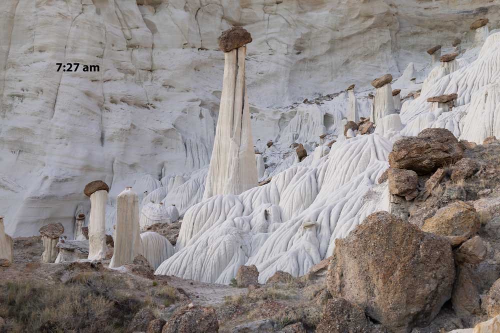
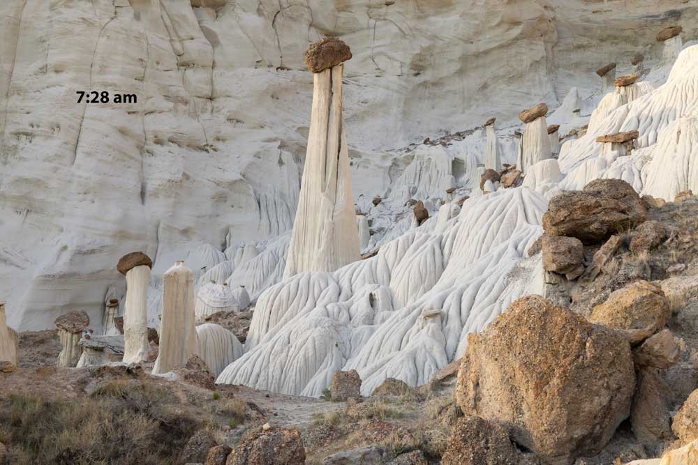
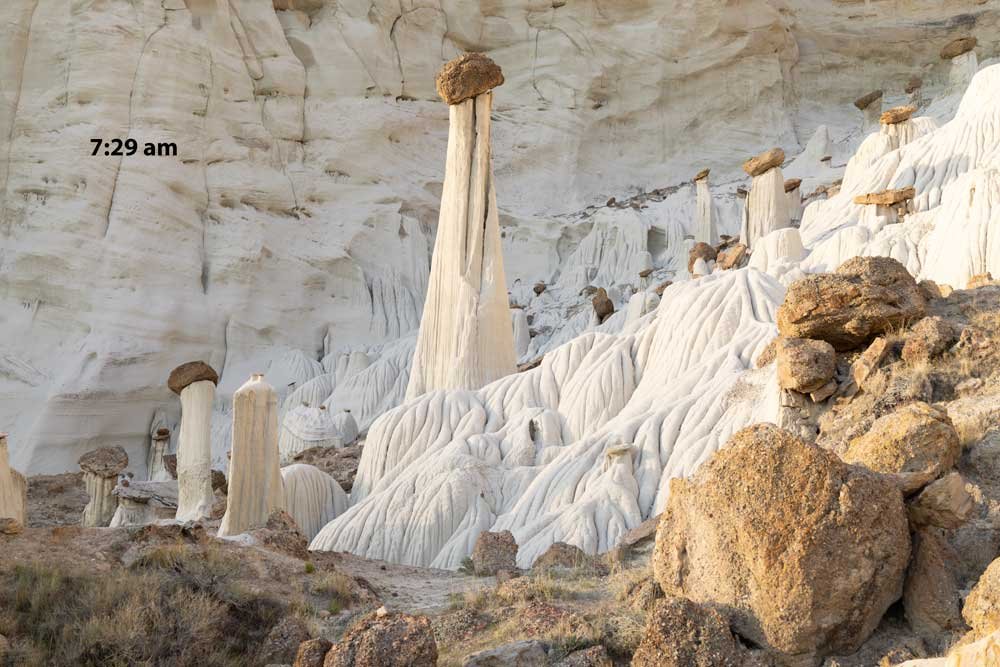
Below is a sequence of shots ranging from 7:27 am to 7:34 am (on a morning when the stated sunset was 6:53 am.
Notice how the contrast with the back wall vs. the hoodoos changes. This is because, in mid-April, the side wall begins to block the sun from the back wall as the sun rises and moves further south. In just a few more minutes, the whole scene will be in shadow).
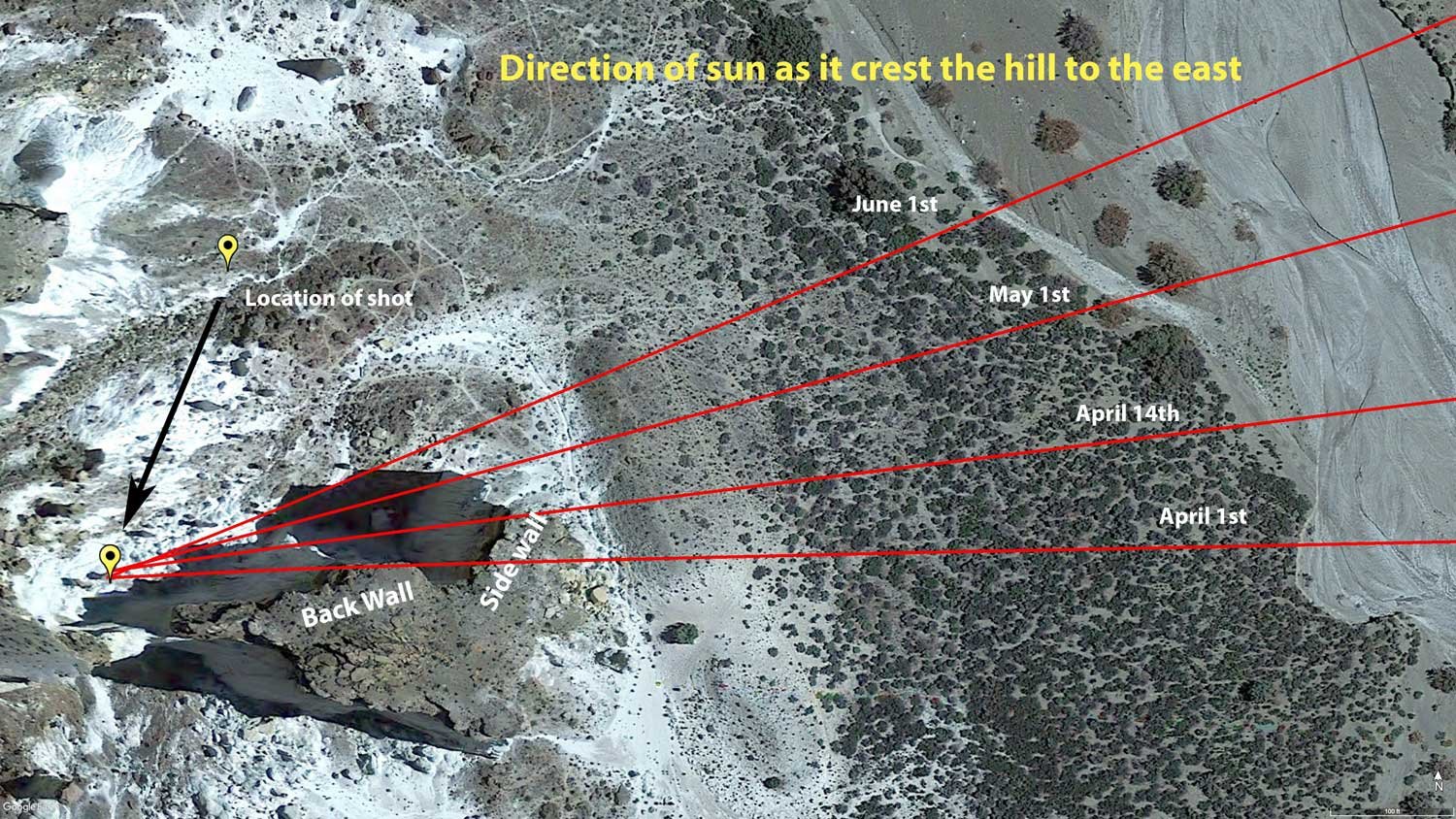
Best Time of Year
The hoodoos can be photographed any time of year (preferably early morning) and get a nice shot. However, because the hoodoos are situated in a small protected area with tall walls behind and to the left of it (see image below), the phenomenon of the scene shown above can only happens when the first light of the sun (as it crests the hill to the east) is north of the side wall. Otherwise, the hoodoos will not receive direct sunlight.
In the winter, the sun rises too far to the south and will be blocked by the side wall. In the summer, the back wall will be illuminated, and it will be too damn hot! For this reason, the best time of year would be around mid-April to around mid-May.
By sheer luck, we visited the Wahweap Hoodoos on April 14th and were able to get the correct shot. A few days earlier might have provided us with a long walk for nothing.
Lens(es) Needed
In addition to the shot above, there are plenty of other photographic opportunities in and around the hoodoos. Having focal lengths ranging from 24-105 mm should provide adequate coverage.
The shot above was taken at 48mm.
Birds-Eye View From Google Earth Pro
Permits
At the time of this writing (Aug 2022), there are no permits required in the area.
Direction of the Shot
The direction of the shot is south, around 190°.
Equipment Needed
As mentioned, the hike to the Wahweap Hoodoos is challenging, so you want to pack as little as possible. What equipment you bring will partly depend on whether you are hiking the night before (and staying the night) or hiking early in the morning. We chose to walk the night before and tent camp. By hiking the night before, you can survey the area and get some nice shoots around the hoodoos during the blue hour. However, you must pack in a tent, sleeping bag, pillow, snacks, and other liquids. The overnight temperatures in mid-April can easily get down into the 30's°.
The hike takes about 2 to 2.5 hours each way. So if you are hiking in the early morning - you should probably be on the trail around 4 am. Hiking in the early morning can lighten your load but can make for a very long day on your old tired feet.
From a photography standpoint, you "could" potentially get by without a tripod (but I would not recommend it) as the scene could be photographed handheld at a higher ISO and smaller aperture. The image above was taken at 100 ISO, with a 1/60th second shutter speed at f8.0.
I carried in 4 quarts of liquid (water and Gatorade) - and cached 2 of the quarts along the hike to lighten my load and have them for the return trip. A floppy hat, sunscreen, and energy bars make the journey more enjoyable.
Number of Other Photographers to Expect
Hiking 9 miles, in the open sun, in the middle of nowhere, will not attract many tourists. However, the spot you need to stand to take the shot above can only accommodate about 3-5 photographers (with tripods), so the early birds gets the worm.
When we were there, we saw three other groups of people: 1) a couple of hikers and an Instagram shooter (who both left before sundown) and 2) another set of hikers/campers that stayed the night (not photographers).
Weather
The area around Big Water, UT, is a high desert climate where temperatures can vary up to 40-50° daily. In the spring, the temperatures at night can dip down into the 30's° at night to reach into the 80's° in the afternoon.
Cell Service
I have Verizon, and there is no cell service at the Wahweap Hoodoos. You will have cell service in the parking area.
Overnight Camping Options
The Wahweap Hoodoos are located on Grand Staircase Escalante National Monument land, which is open for public camping. However, there is no water or other resources whatsoever.
Nearby Restaurants
The closest community to the Wahweap Hoodoos is Big Water, UT - which I do not believe has any food options. Page, AZ is 25 miles from Big Water.
In Page, AZ - click on the restaurant below for yelp review
Dam Bar & Grille
(928) 645-2161
644 N Navajo Dr, Page, AZ
El Tapatio
(928) 645-4055
25 Lake Powell Blvd, Page, AZ
Birdhouse
(928) 645-4087
707 N Navajo Dr, Page, AZ