
Abiqua Falls

ABIQUA FALLS
Near Scotts Mills, OR
Image by Patrick Campbell @www.patrickcampbellphotography.com
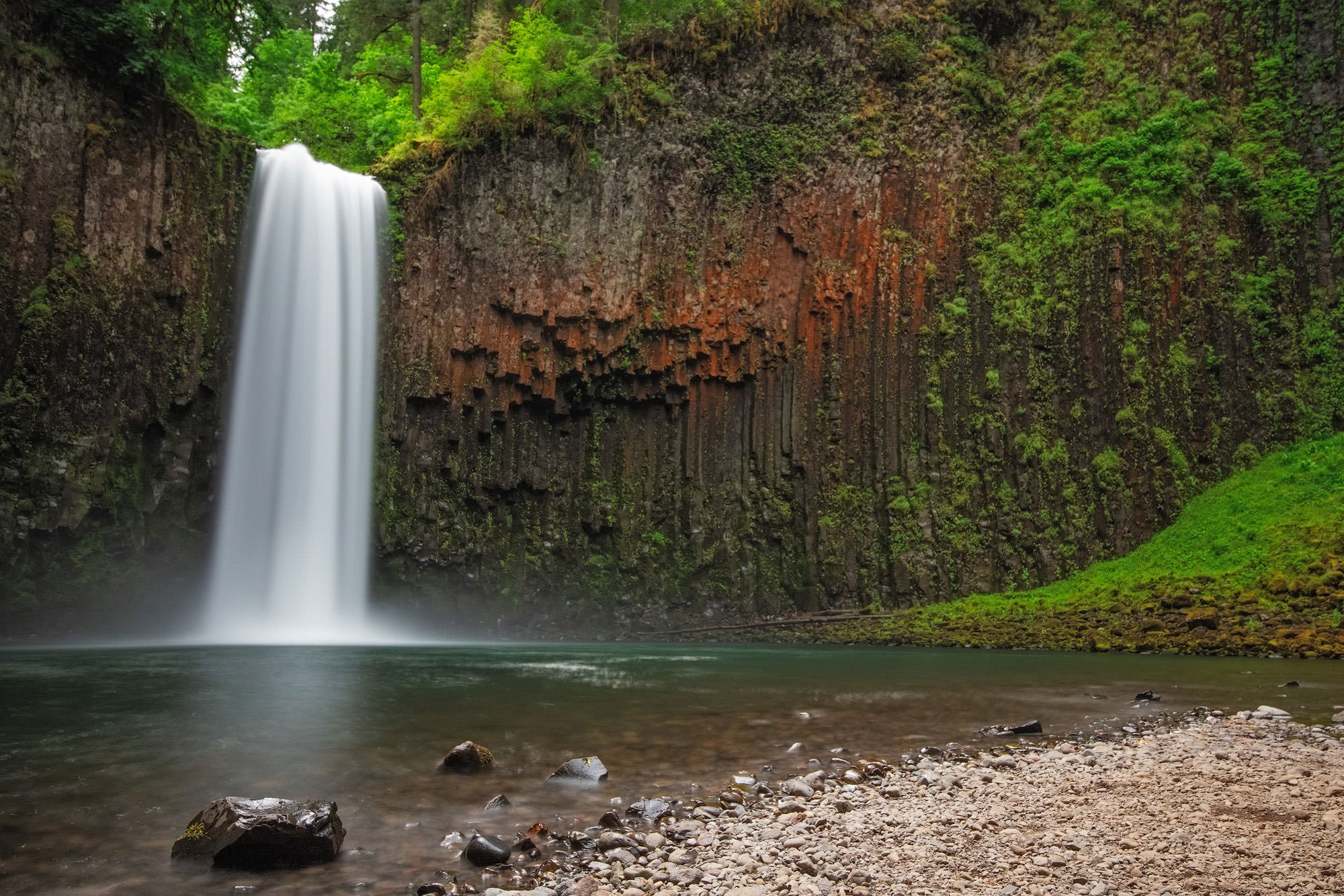
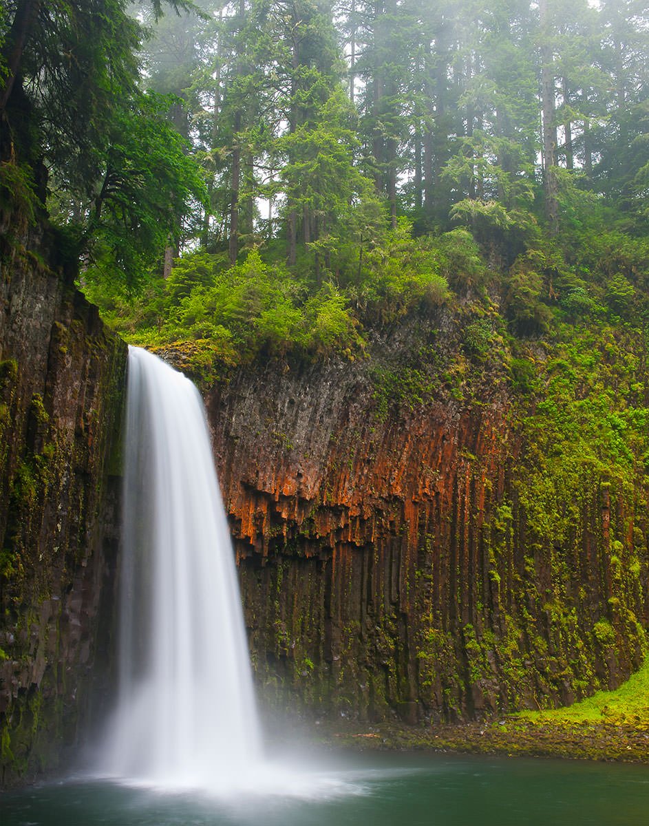
One of the most scenic waterfalls in Oregon, Abiqua Falls is a 92 foot waterfall nestled in cliffs of red tinted columnar basalt, tumbling into a large pool at the base of the falls. A pebbly beach with boulders, moss, ferns and old growth forest at the top of the cliff walls, and the outflow of Abiqua Creek offer numerous photographic compositions.
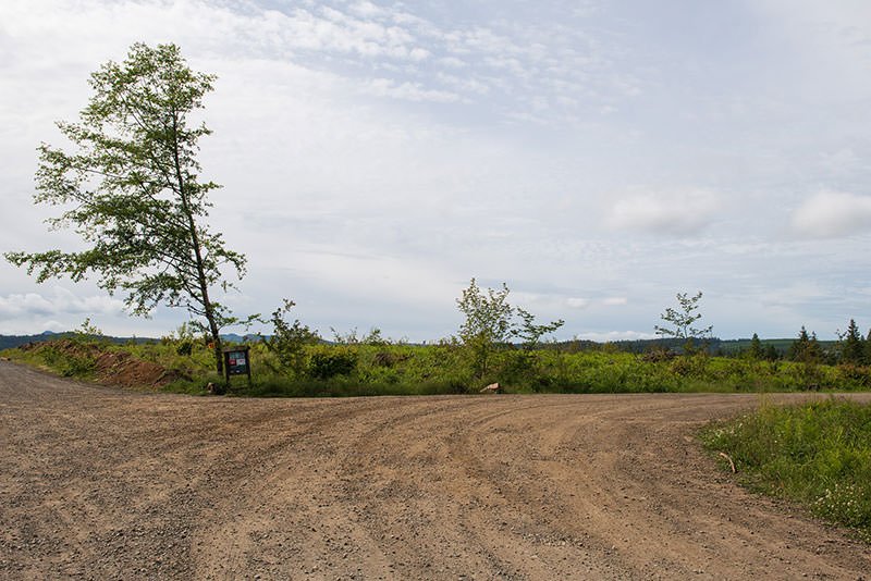
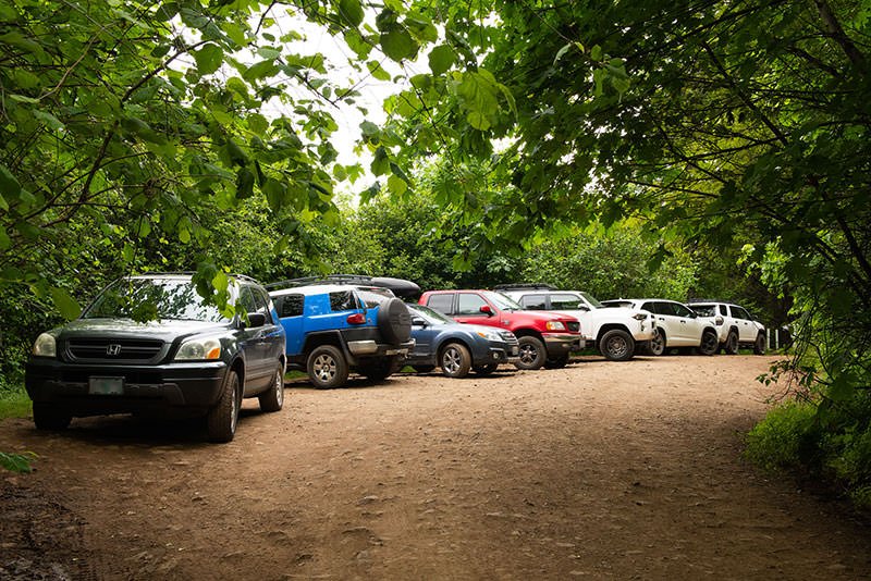
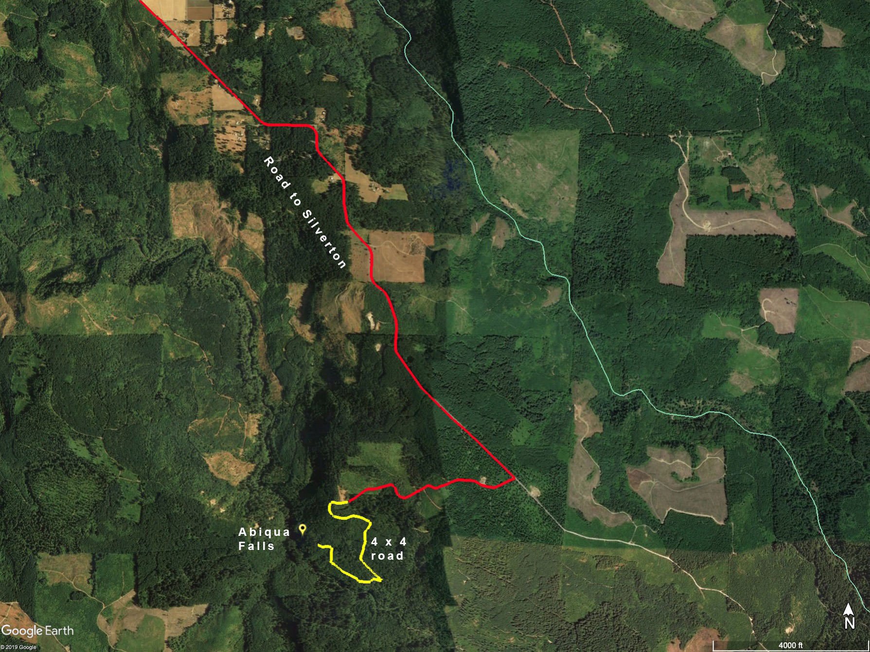
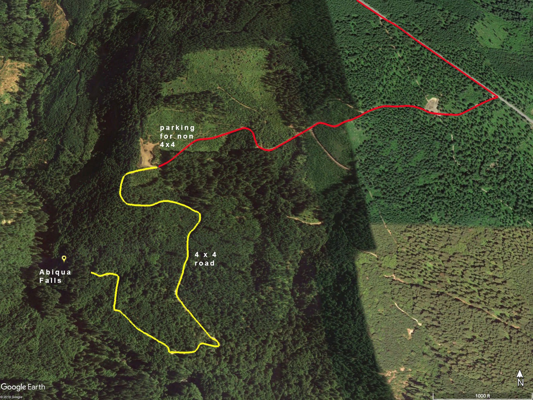
The falls are 33 miles east of Salem, out of the small town of Scotts Mills, in the foothills of the Oregon Cascades. The area receives about 70 inches of rain a year, and is lush and green year around. The falls are on private property owned by Mt. Angel Abbey, but the area is open to the public. Most of the road to the trailhead is paved. However, the last two mile stretch is a gravel and dirt with large potholes, exposed rock, and ruts. High clearance, 4WD vehicles only are recommended for this section. At the end of the road is a steel gate, and a small wide area that will fit about a half dozen vehicles.
Photos and location summary by Patrick Campbell
Trail Difficulty - HARD
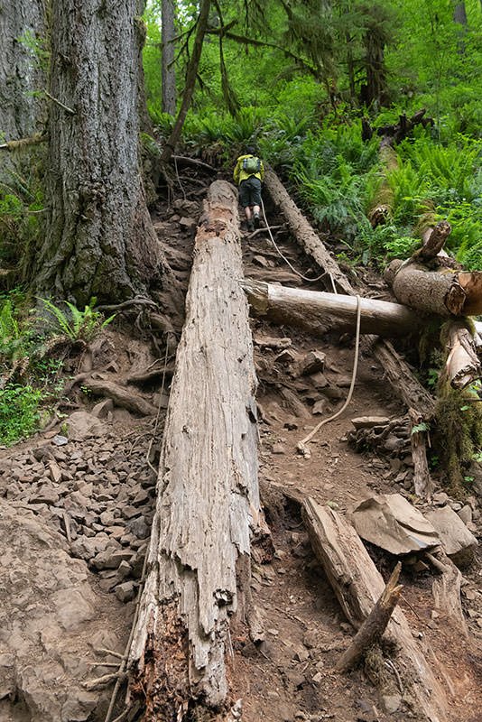
I would rate the difficulty of the trail to this specific location as a 4 on a scale of 1-5 (with 5 being most difficult). The trail down to the falls from the end of the road is only about 0.9 mile each way, with about a 300 ft elevation loss/gain. It is unmarked, and near the road are some false trails that led to a cliff. The true trail is well travelled, but very steep in places, particularly the last section, which has about a 70 per cent grade. On this last section are two sets of ropes that are parallel to the trail. After a recent rain the trail will be very muddy and very slippery. When you reach the creek, you will have to do some rock hopping upstream to get to the falls. For some compositions you will want to wade to the far side of the shallow creek, so bring water shoes, waterproof boots, or waders.
For those without a high clearance 4WD vehicle, you can park farther up the road, and add an additional 1/2 to 2 miles each way and up to another 1100 feet of elevation loss/gain.
GPS Coordinates & Elevation
1,200 Ft. Elevation
View In Google earth
Download KMZ Trail File
Click Here to download the KMZ file for this location.
Directions
CLICK HERE to get driving directions to Abiqua Fall trailhead
From Portland, OR
From Portland, drive south on I-5 and take I-205 toward Oregon City. In Oregon City, drive south on Hwy 213 for 21.2 miles and turn left on the Mt. Angel - Scotts Mill Rd. NE (before Silverton). Drive on Mt. Angel - Scotts Mill Rd. NE for 2.3 miles and take a right on Crooked Finger Rd. Stay on Crooked Finger Rd. for 10.8 miles. At this point, take a right on a dirt road for about a mile and you will see an open area to park (if you don’t have a 4 x 4 vehicle). If you have a 4 x 4 vehicle, you can continue down the dirt road for 1.2 miles until you get to the Abiqua Falls trailhead.
From Silverton, OR
When leaving Silverton, take OR-213 N/Oak St for 3.2 miles and turn right on N Abiqua Rd. Travel on this road for 3.8 miles and turn left on to McKillop Rd. Continue on McKillop Rd for 1.9 miles and take a slight right onto Crooked Finger Rd NE. Stay on Crooked Finger Rd NE for 7.5 miles. At this point, take a right on a dirt road for about a mile and you will see an open area to park (if you don’t have a 4 x 4 vehicle). If you have a 4 x 4 vehicle, you can continue down the dirt road for 1.2 miles until you get to the Abiqua Falls trailhead.
Once on the road down to the falls, go straight at two junctions. The road narrows to one lane. At 1.2 miles the road becomes very rough with large potholes and high ridges. At this point, a 4 WD vehicle with high clearance is highly recommended.
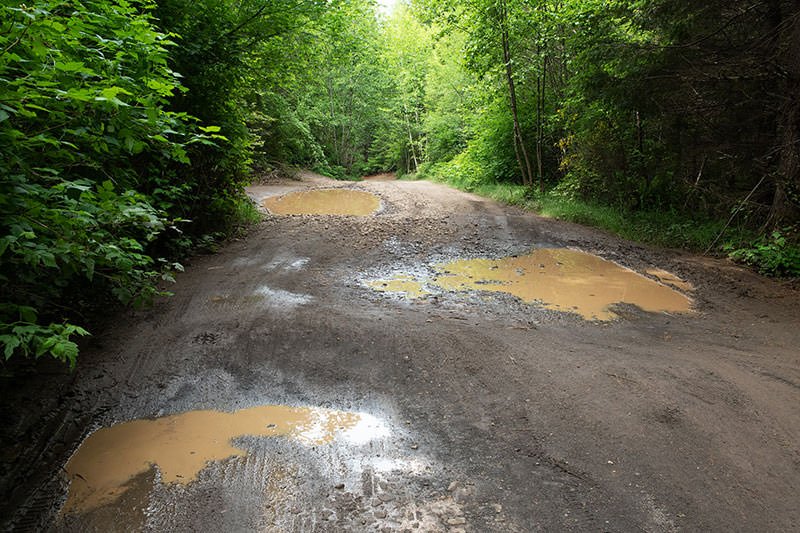
There are pullouts before and after this section if you want to park and walk the rest of the way. At the end of the road, about 2 miles, there is a locked metal gate. Park just before this gate.
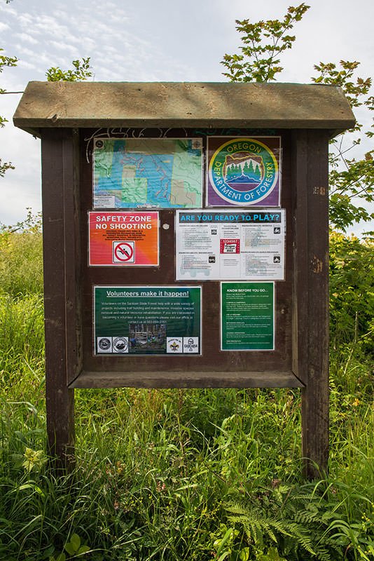
Once parked, look for either one of two dirt trails that start on the downhill side of the road. The further one has a sign on a tree announcing you are on Abbey Foundation private property.
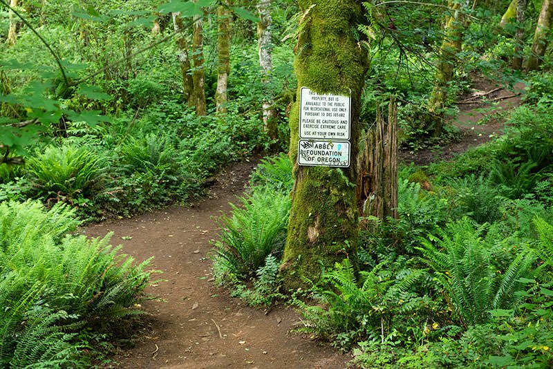
Shortly you will reach a dirt hump. Walk over this hump to the left and keep bearing left downhill on the narrow but well-traveled trail. There are other trails leading to a fire circle and a cliff shortly beyond the fire circle. DO NOT take this trail. Backtrack to the dirt hump and down the well-traveled narrow trail. There are several small downed trees over the trail. The trail soon becomes very steep, with a series of ropes along the trail to semi-rappel down the steepest parts.
WARNING: the last part of the trail is VERY slippery on rainy days and after it rains (which is often). Even in dry weather the trail is slippery. Wear sturdy boots, gloves, and prepare to get muddy. Your tripod should be strapped to your photo backpack. Consider bringing a trekking pole with you.
Once you reach Abiqua Creek, work your way upstream for about ¼ mile until you come to the falls.
IMPORTANT: there are no services after Scotts Mills, and only a small grocery store in Scotts Mills, so take the 10 essentials with you. Pack it in, pack it out.
On the way back to Portland, there is an easier return route that goes through the outskirts of Canby. Return to Marquam and follow the signs to Canby and I5. You’ll eventually merge onto I5 just south of Wilsonville.
Photography Tips
As this location has become more well known and more popular, I recommend visiting on a week day, and as early in the day as possible, especially in the summer. It is rare to have the place entirely to yourself.
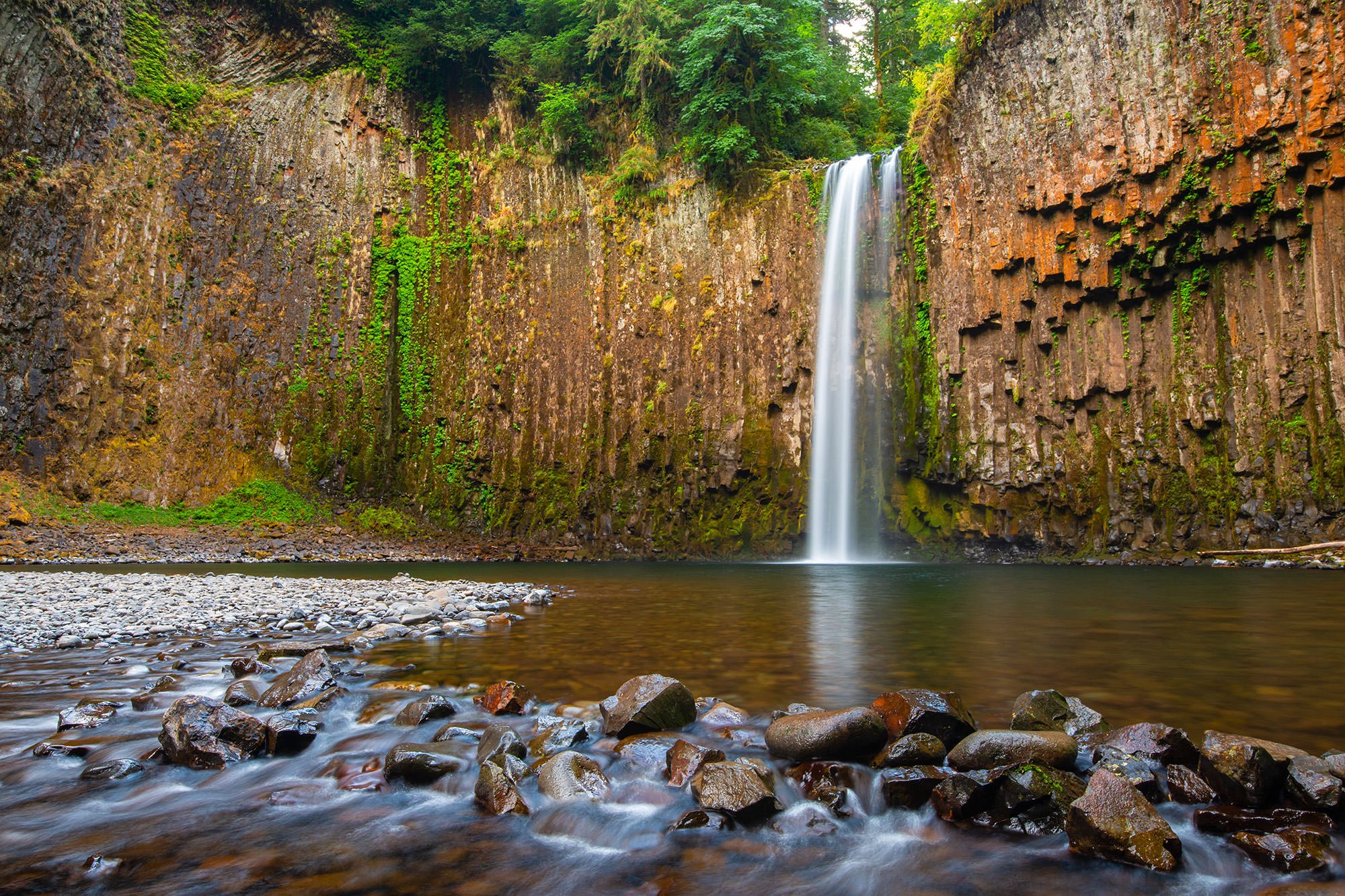
Other angles of the falls to consider
Best Time of Day to Shoot
The waterfall faces northwest, but it is in a rocky bowl surrounded by tall, old growth forest. Therefore, sunlight only reaches the falls and the pool in front of the falls in the middle of the day, so either early or late in day will offer indirect sunlight. Cloudy days, in general, are better for avoiding harsh light on the water.
Best Time of Year
I find the best time to visit the Abiqua Falls is late summer to early fall, as the water volume from the falls has diminished and mist is not so much of a problem. There is still enough moisture to keep the ferns and moss green and the creek is easier to cross. However, the location is more popular with hikers that time of year as well.
The falls can also be photographed in mid-winter, after a snowstorm. Occasionally, the splash pool below the falls will freeze over, but that is a rare event.
The image above was taken on June 26th
Lens(es) Needed
Wide-angle to short telephoto. 16mm is more than wide enough to capture the waterfall and surrounding bowl. I have also used 16-35mm and 24-70mm zooms to photograph the falls.
The image above was shot at 24mm.
Birds-Eye View
Permits
At the time of this writing (March 2020), there were no permit required.
Direction of the Shot
The direction of your shot into the falls is around 90°.
Equipment Needed
You will need a tripod, a polarizer (to decrease water reflections), and possibly a neutral density (ND) filter to reduce your shutter speed to 1/2 second or longer to create the silky water flow.
During the wetter months (November through May), the force of the rushing falls will produce lots of mist, which will end up on your lens and camera. Be prepared to shield your camera / lens with an umbrella, hat, or other item. Bring a rain sleeve for your camera and lots of micro and lens cloths to wipe down your equipment.
There are some nice vantage points across the creek at the edge of the splash pool in front of the falls. Consider bringing aqua socks or waterproof boots, and a trekking pole, to safely cross the creek and avoid getting your boots (and possibly your camera) soaked.
Number of Other Photographers to Expect
Even though Abiqua Falls is somewhat difficult to reach, it has become a popular hiking destination, especially in good weather. Unless you go very early in the day, expect other people (not necessarily other photographers) to be there.
Weather
Cell Service
There is no cell service at the is location.
Lodging & Camping
The closest town to the Abiqua Falls is Silverton which is a great little town with lots to do and many places to stay.
Nearby camping and lodging
Camping - click on the campground below for directions
Abiqua Creek Serenity campsite (15 miles)
Camp Dakota (3 miles north)
Silver Falls State Park (22 miles)
Lodging - click on the lodging below for a TripAdvisor review
Silverton Inn and Suites
(503) 873-1000
310 N Water St, Silverton, OR
Oregon Garden Resort
(503) 874-2500
895 W Main St, Silverton, OR
Nearby Restaurants
As mentioned, Silverton is a great little town about 70 minutes south of Portland. It is a nice place to visit, enjoy and grab a nice meal.
Nearby Restaurants - click on the restaurant below for yelp review
Creekside Grill
(503) 873-9700
242 S Water St, Silverton
Gather
(503) 874-4888
200 E Main, Silverton
Mac’s Place
(x503) 873-2441
201 N Water St, Silverton
Area Guides and Workshops
None