
Sahalie Falls

SAHALIE FALLS
Three Sisters Wilderness, OR
Sahalie Falls is a powerful, but little heard of water fall along the McKenzie River in central Oregon. The destination of the falls is easy to find (right off of the road) and the intense water flow makes this spot a must stop while in Central Oregon.
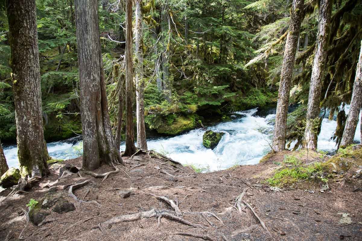
The view of the Sahalie Falls visitors stand is a simple postcard shot. However, the picture above was taken down the trail about 100yds. and along on the banks of the McKenzie River. I have sat in the spot for hours just taking in the sounds and peaceful nature of the falls.
Images and location summary by Tim Wier
Trail Difficulty - MODERATE AND RISKY
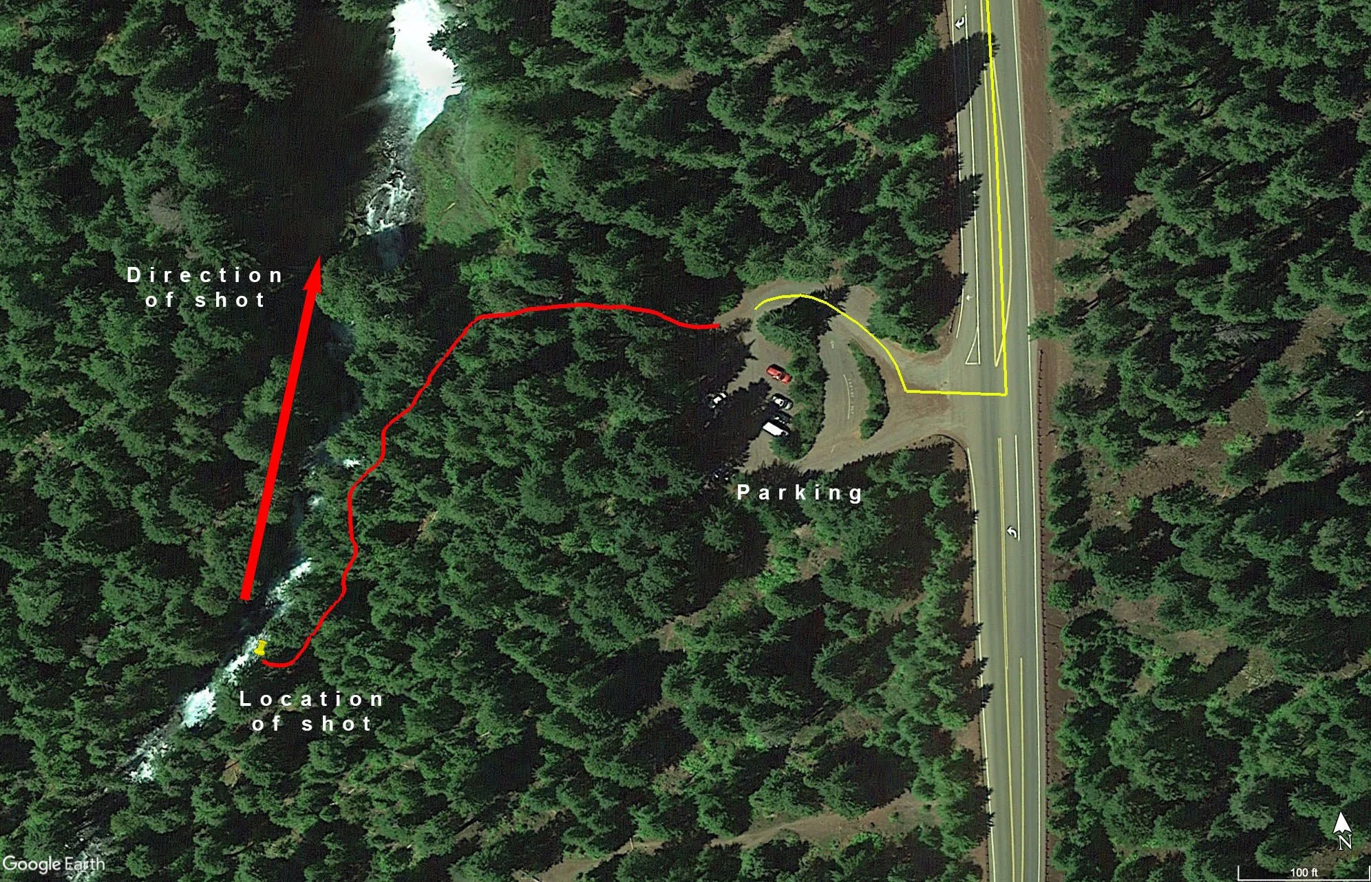
I would rate the difficulty of this trail as a 3 on a scale of 1-5 (with 5 being most difficult). The location of this shot is an easy 200yd. walk from the Shalie Falls parking lot directly off of OR-126. The reason for rating this as a 3 is because to get to the location of this shot you have to hike down a short but serious slope to the banks of the McKenzie River. Caution at this location is paramount, as falling into the McKenzie River would be catastrophic.
GPS Coordinates & Elevation
2,861 ft. Elevation
View In Google earth
Download KMZ Trail File
Click Here to download the KMZ file for this location.
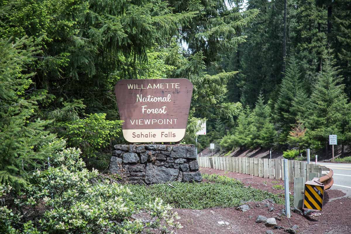
Directions
CLICK HERE to get driving directions the Shalie Falls trailhead and parking lot.
The closest town to Sahalie Falls is Sisters, OR (34 miles east).
From Sisters, OR, drive approximately 29 miles west on US-20 and turn LEFT (south) onto OR-126 for 5.3 miles. The parking lot for Sahalie is on the right (west) side.
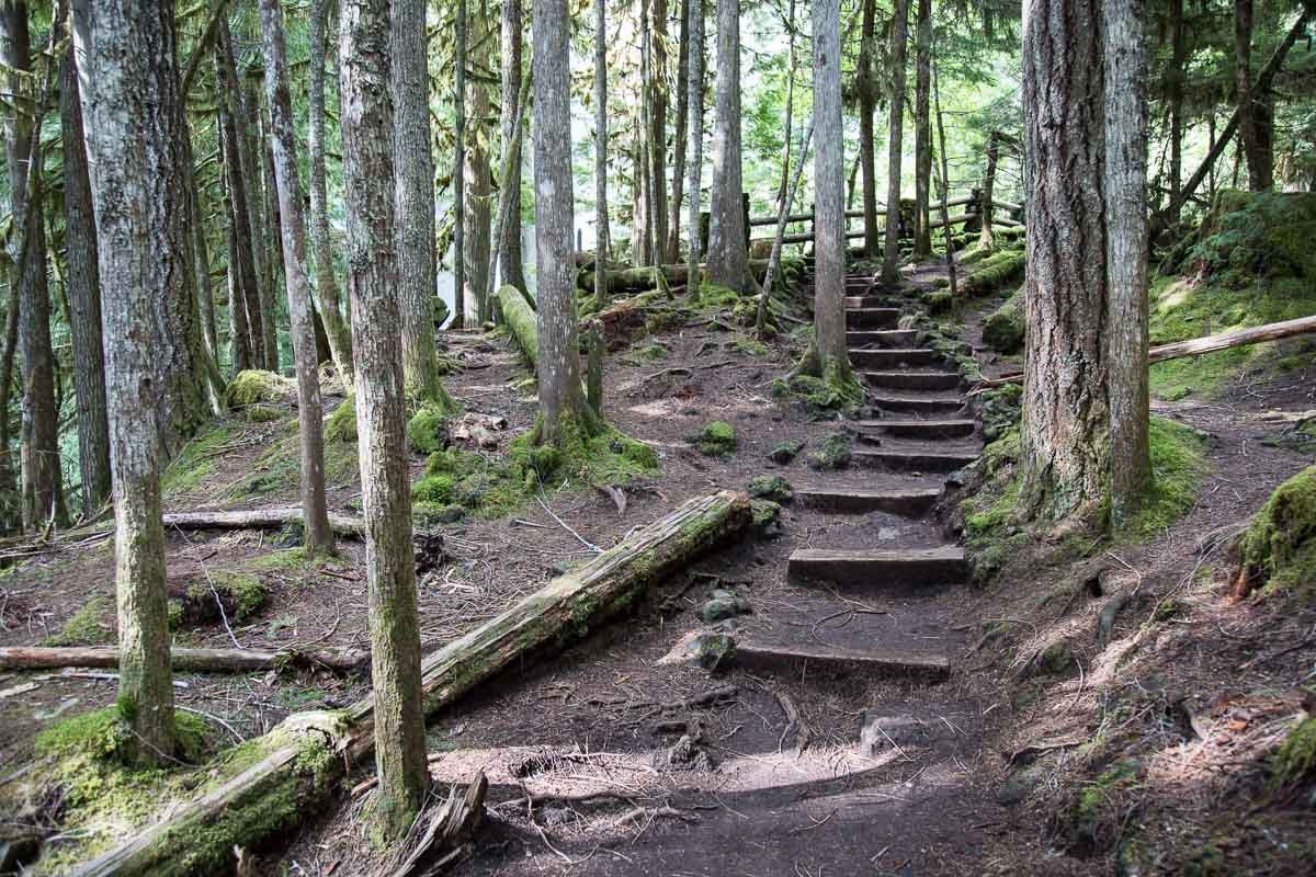
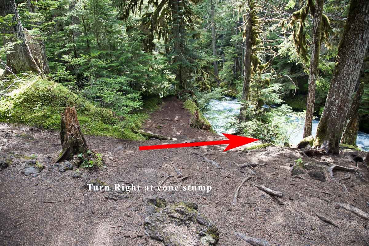
From the parking lot, walk the easy 25yds. to the visitors stand. After you take in the grandeur of the falls from the visitors stand, continue down the trail for another 100yds. or so. After you go down a series of wooden steps, look for a short (2ft.) cone shaped tree stub on the right side of the trail. At the cone shaped tree stub, look right toward the McKenzie River. You will see a trail down to the banks of the river.
Carefully walk down the steep trail and you are there. As mentioned, caution at this location is paramount, as falling into the McKenzie River would be disastrous.
Photography Tips
To get to the location of this picture, you have to walk down a slope off of the main trail and sit along the McKenzie River. There are several different compositions from this spot: wide angle, standard, or compression.
EXIF Data
Focal Length – 24 mm (4 shots vertical pano)
Exposure – 1 sec @ f 8.0
ISO – 100
Date – May 22nd
Time – 4:48 pm
Best Time of Day to Shoot
The best time to shoot is either on an overcast day or in the late afternoon once the sun is blocked by the trees and shade drapes over the McKenzie River.
Best Time of Year
This shot can be taken in the spring, summer, and fall, as long as the powerful McKenzie River is flowing. For me, the best time of the year would be in the fall (mid to late October), when the underbrush and trees are in peak color.
Lens(es) Needed
The shot above was made by stitching together 4 shots vertically with a 24mm lens and panoramic tools. You can use anything from a 11mm to a 100mm lens, depending on the composition you are looking for.
Birds-Eye View
Permits
There are no permits required.
Direction of the Shot
The direction of the shot is north at 23°.
Equipment Needed
You will need a tripod, a polarizer, and a neutral density (ND) filter to reduce your shutter speed to ½ second or longer to create the silky water flow. The shot above was made by stitching together 4 shots vertically with panoramic tools. If you plan on using this technique, you would need the appropriate equipment.
You may also want use a tilt/shift lens to compensate for the slight keystone effect on the trees while pointing down toward the river.
Number of Other Photographers to Expect
Sahalie Falls can be moderately busy at times, with several hikers on the trail. However, this location is off the trail a few feet toward the river, so rarely do other hikers or photographers find this location.
Weather
It rains a great deal in this part of the country, so make sure you travel with rain gear. It can get cold in spring and fall so make sure you travel with the appropriate cold weather equipment in spring and fall. The road to Proxy Falls in closed in the winter.
Cell Service
I use Verizon, and the cell service in at this location is spotty at best.
Lodging & Camping
Sahalie Falls is in rural central Oregon, and the closest town is Sisters, OR (35 miles east). The closest larger towns are Bend, OR (60 miles southeast), Salem, OR (90 miles northwest), and Eugene, OR (70 miles west). Each of these larger towns has an abundance of lodging. Sisters, OR is a nice little town with decent lodging.
Nearby camping and lodging
Camping - click on the campground below for directions
Coldwater Cove Campground (.5 miles)
Olallie at McKenzie Bridge (7.5 miles)
Limberlost Campground, OR (16 miles)
Lodging - click on the lodging below for a TripAdvisor review
Five Pine Lodge & Spa
(541) 549-5900
1021 E Desperado Trail, Sisters, OR
Best Western Ponderosa Lodge
(541) 549-1234
1500 Highway 20 W, Sisters, OR
Nearby Restaurants
Sisters, OR, is a small town, but has some good eating establishments. Some of my favorites are Three Creeks Brewing, Cottonwood Café, and Los Agaves. Each are nice places for a lunch/ dinner and a beverage.
Nearby Restaurants - click on the restaurant below for yelp review
Three Creeks Brewing
(541) 549-1963
721 Desperado Ct, Sisters, OR
The Cottonwood Café
(541) 549-2699
403 E Hood Ave, Sisters, OR
Los Agaves Mexican Grill
(541) 549-0777
5291 E Cascade Ave, Sisters, OR
Area Guides and Workshops
None