
Ponytail Falls

PONYTAIL FALLS
Columbia Gorge, OR
Ponytail Falls is a simple falls located just above the much more famous Horsetail falls in the Columbia Gorge. However, it is one of the prettiest waterfalls in the gorge and it can produce some great photographic opportunities.
You can shoot these falls from many different angles: from the trail to the left, from the right of the creek, placed in the creek, or from behind the falls (as the trail goes behind the falls).
Location summary by Tim Wier
Trail Difficulty - MODERATE
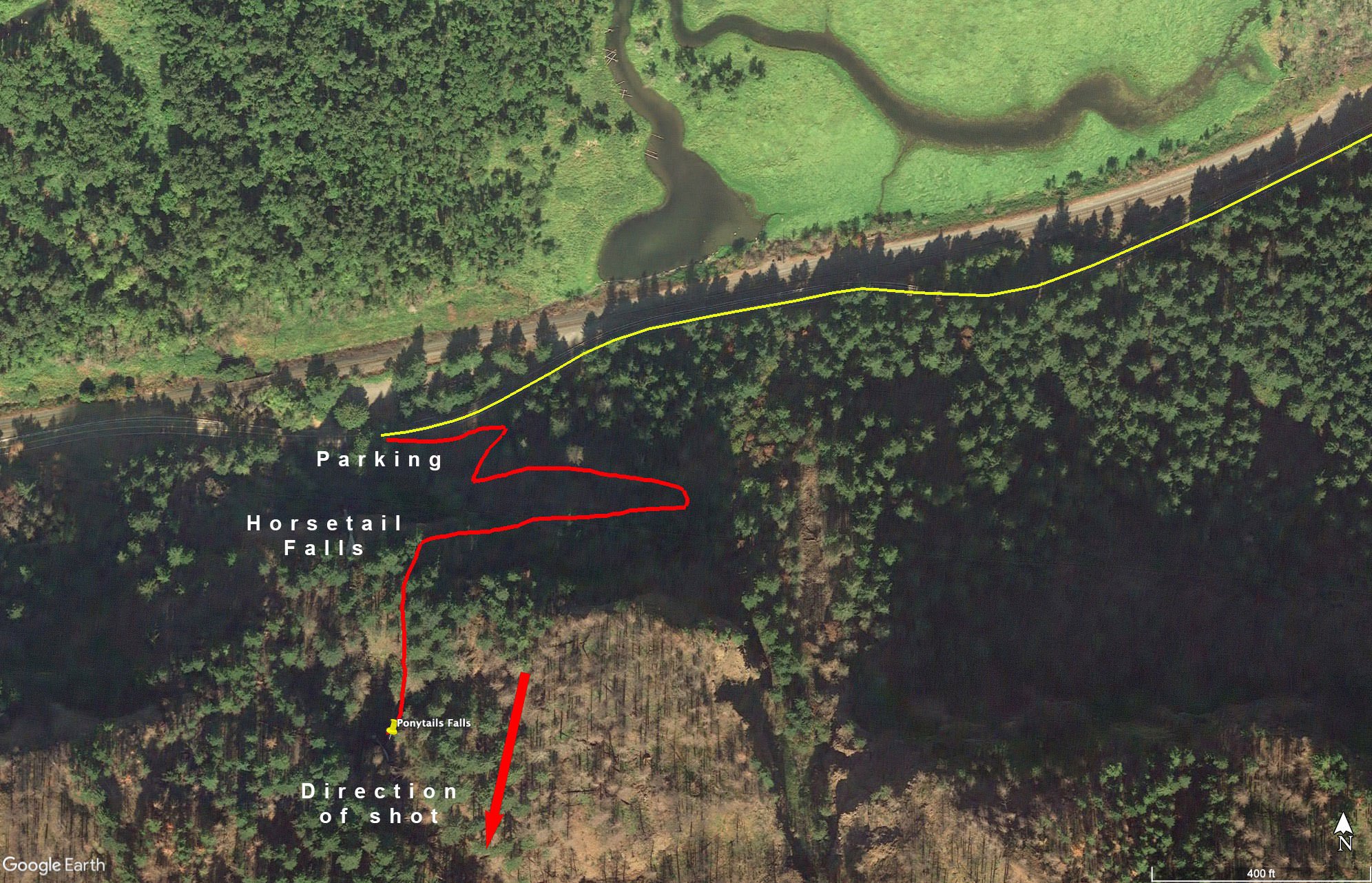
I would rate the difficulty of this trail as a 3 on a scale of 1-5 (with 5 being most difficult). The hike on the Horsetail Falls #438 trailhead is a fairly strenuous ¼ mile hike up a steep hill with several switchbacks. Once you get to the falls, you will need to hike down 20yds. or so to the Horsetail Creek and find the best position to compose your shot.
I would suggest bringing waders/wet shoes as you will most likely be walking/standing/sitting in water.
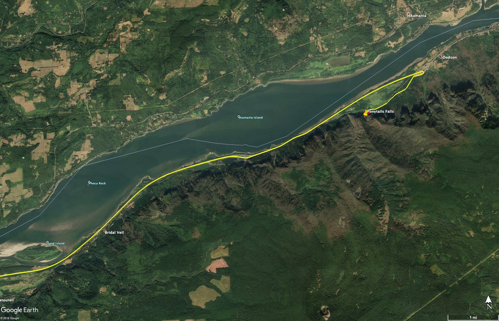
GPS Coordinates & Elevation
80 Ft Elevation
View In Google earth
Download KMZ Trail File
Click Here to download the KMZ file for this location.
Directions
CLICK HERE to get driving directions the Ponytail Falls trailhead/parking lot.
From Portland, OR, travel east on I-84 for approx. 30 miles and take exit 35 (Ainsworth). Once you exit I-84, circle back and get on the Historic Columbia River HWY for 1.5 miles until you see a large parking lot on the right and a very large waterfall on the left (Horsetail Falls).
From the parking lot, find the Horsetail Falls #438 trailhead and begin your ¼ mile hike to Ponytail Falls. The hike is steep for most of the way, and after a series of switchbacks you will turn a corner to the left and the Ponytail Falls will be right in front of you.
Photography Tips
There are multiple ways to shoot this location: 1) from the trail looking down on the falls, 2) in the creek looking up at the falls, and 3) from the alcove behind the falls. I would explore each to find the composition that is best for you.
EXIF Data
Focal Length – 24 mm
Exposure – 1 sec @ f 8.0
ISO – 100
Date – June 16th
Time – 2:30 pm
Best Time of Day to Shoot
The best time to shoot is late afternoon/evening, after the sun has crested the ridge behind the falls.
Best Time of Year
Spring, summer, and fall are all good times to shoot this nice little falls. However, late fall would be the very best time to shoot, as the underbrush around the falls adds color to the scene.
Lens(es) Needed
The above shot was taken with a 20mm lens. Depending on the composition you are looking for, you can use anything from a 16mm to a 35mm lens.
Birds-Eye View
Permits
There are no permits required.
Direction of the Shot
The direction of the shot is south at 170°
Equipment Needed
You will need a tripod, a polarizer, and a neutral density (ND) filter to reduce your shutter speed to ½ second or longer to create the silky water flow. The spray from the falls can create problems with water on your camera/lens, so I would suggest you bring some kind of rain sleeve for your camera and lens cloth to wipe down your lens.
Another item to consider are waders/wet shoes, as you will most likely be walking/sitting in water.
Number of Other Photographers to Expect
Ponytail Falls is set along the moderately busy Horsetail Falls Trail (the trail runs directly in front of the falls while you are shooting). The trail attracts a ton of hikers and tourists, but not that many photographers.
Weather
It rains a great deal in this part of the country, so make sure you travel with rain gear. It can get cold in spring and fall, and winters are usually wet and very cold. Make sure you travel with the appropriate cold weather equipment in spring, fall, and winter.
Cell Service
I have Verizon and my cell service was working while in the parking lot, but I lost cell coverage as I hiked up to the falls.
Lodging & Camping
Ponytail Falls is located between Cascade Locks, OR (11 miles east) and Troutdale, OR (20 miles west). The closest city is Portland, OR (45 miles west). The Portland metropolitan area has many choices for lodging. Cascade Locks and Stevenson are smaller towns but do have several lodging options.
For camping, I stay at Ainsworth State Park (1 mile east). Ainsworth State Park is a traditional campground with about 40 RV hookups and tent sites. Alternatively, Eagle Creek campground (9.0 miles east) is small with 16 sites. It does not have RV hookups and fills up quickly.
Nearby camping and lodging
Camping - click on the campground below for directions
Nearby Restaurants
Cascade Locks, OR, is a nice little community. My favorite place to eat is the Cascade Locks Ale House. They have GREAT pizza with a good selection of local brews.
Stevenson, WA, is a nice little town with some good places to eat. I have had many a good meal and cold beer at the Big River Grill directly across for the Stevenson Elementary School. It is nice place with good food and friendly folks. Also Joe’s El Rio Mexican Café across the street has very nice people, pretty good Mexican food, and great margaritas.
Nearby Restaurants - click on the restaurant below for yelp review
Cascade Locks Ale House
(541) 374-9310
500 NW Wanapa St, Cascade Locks, OR
(971) 231-4599
515 NW Portage Rd, Cascade Locks, OR
Big River Grills
(509) 427-4888
192 2nd St, Stevenson, WA
El Rio Mexican Cafe
(509) 427-4479
193 2nd St, Stevenson, WA
Area Guides and Workshops
If you were looking for a GREAT photography guide for Pacific Northwest (Oregon and Washington areas) - I can highly recommend Mark Metternich. I have taken workshops with Mark in the past and he has been hosting workshops in the Pacific Northwest for many years.
Mark knows all the VERY best places to take you and just the right time to be there - to help you get the shot. He is a great photographer, an expert at photoshop, an excellent guide/instructor and a super nice guy.
Mark Metternich
www.markmetternich.com
Mark@MarkMetternich.com